Author(s): Aibek Samakov and Marc Foggin, with contributions from Taghi Farvar, Irakli Goradze, Holly Jonas, Ruben Khachatryan, Bassima Khatib, Nejat Malikyar, Ali Razmkhah, Jessica Stewart, and Engin Yilmaz; and editorial support by Matthew Emslie-Smith, Holly Jonas, and Jessica Stewart.
Indigenous peoples and local communities govern and conserve vast territories of life across the breadth of West and Central Asia and the Caucasus. These territories are found in all geoclimatic and sociopolitical regions and are highly diverse in their ecological and cultural characteristics. However, in nearly all instances, people and land are intricately connected through people’s livelihoods and their territories of life are intertwined with culture and sense of identity. Local communities and Indigenous Peoples who effectively govern, manage and conserve their land and biodiversity contribute not only to local affairs, but also to national and global goals as expressed, for example, in the Sustainable Development Goals (SDGs) as well as goals set out in the Convention on Biological Diversity (CBD) and future targets under the post-2020 Global Biodiversity Framework. Their lands, livelihoods and cultures also overlap substantially with globally recognized biodiversity hotspots and Key Biodiversity Areas (KBAs). In this document, the current status and condition of territories of life across the region are reviewed – drawing attention to the inherent richness and diversity of the region’s territories of life as well as the many ways in which each of their current states and the unique threats they face and emerging opportunities vary significantly. Conversely, global trends such as climate change and economic globalisation are likely to affect all of them, adversely, in similar ways. While this report offers a long-overdue synthesis of the diversity of ICCAs or territories of life in West and Central Asia and the Caucasus, additional country-level participatory and community-led studies are also encouraged in order to more comprehensively identify locally pertinent status and trends as well as to highlight the most important threats and opportunities for each country’s specific indigenous and local communities and their respective territories of life, for the benefit of all.
Ecovillage in Armenia. Photo: Ruben Khachatryan
Introduction
This report has three primary aims:
to illustrate the diversity and current status of territories and areas governed, managed, and conserved by custodian indigenous peoples and local communities[1] (hereafter abbreviated as ICCAs or territories of life) in the West and Central Asian region,[2]
to outline some of the main threats to and opportunities for territories of life in the region, and
to offer a starting point for deeper and broader documentation, exploration, analysis, advocacy, and strengthening of territories of life across West and Central Asia
Indigenous peoples and local communities
The terms ‘indigenous peoples’ and ‘local communities’ require some clarification. This report relies on a set of characteristics outlined in the United Nations Declaration on the Rights of Indigenous Peoples (UNDRIP), which guides in the identification of indigenous peoples, including: self-identification as indigenous nations and peoples; a shared history of suffering injustices, colonisation and land dispossession; a complex web of place-based relationships; language, traditional practices, knowledge, and legal and cultural institutions distinct from those dominant in the national state where they reside; and knowledge, culture and practices that contribute toward more sustainable governance and management of human relationships with the natural world.[3],[4] When referring to ‘local communities’ this report means a self-identified human group that acts collectively in ways that contribute to defining territory and culture through time.[5] Since West and Central Asia represent an enormous region, some groups self-identify as indigenous (e.g., tribes and tribal confederacies in Iran), while others refer to themselves as local communities (e.g., in Central Asian countries). From the perspective of international law, none of the West and Central Asian countries joined the ILO Indigenous and Tribal Peoples Convention 169 (1989), while quite a few of them are signatories to the UN Declaration on the Rights of Indigenous Peoples (2007). During the vote for the UN Declaration on the Rights of Peasants and Other People Working in Rural Areas, the majority of the states from the region supported the declaration. In contrast, some states such as Turkey, Georgia, Armenia and Russia abstained. With the exception of Iran,[6] there are no overviews of country-level legislation on indigenous peoples and local communities and their rights in West and Central Asia, which represents a huge knowledge gap.
Introducing ICCAs – Territories of Life
ICCA is an abbreviation for territories and areas conserved by indigenous peoples and local communities, with a shorter version being territories of life. ICCAs represent a phenomenon with many diverse manifestations and names, present in nearly all cultures and locales around the world. In West and Central Asia[7] and elsewhere, they may also be known as wilayah adat, al-hima, agdal, tagal, qoroq, yerli qorukh, yiyk jer, and as sacred sites or ancestral domains known by their local names.
Over the course of its use, the term ICCA has often been perceived and used in connection to nature conservation.
Although the concepts of ‘territories of life’ and ‘ICCAs’ are synonymous, with exactly the same definitions, the former seems to convey better the views and perceptions of indigenous peoples and local communities themselves in regard to their lands and territories. For example, the term ‘territory of life’ better highlights many of the cultural dimensions of local communities’ interactions with their lands, thus being a positive step toward overcoming culture-nature, human-nature, conservation-livelihoods, and a range of other artificial dualisms. However, recognizing that both terms are still being used, this report uses them interchangeably.
ICCAs – territories of life often share three common characteristics:[8]
There is a close and deep connection between a particular territory, area or wildlife species’ habitat, on the one hand, and an indigenous people or local community, on the other hand. This relationship may be rooted in history, social and cultural identity, spirituality and/or people’s reliance on the area for their material or non-material well-being. Furthermore, it must be recalled that the status of indigenous people and local communities stems from their self-identification and does not require recognition or depend upon ‘approval’ from the outside for their de facto existence.
The custodian people or community makes and enforces decisions about the territory, area or species’ habitat through a functioning governance institution.
Governance decisions and management efforts of the concerned people or community contribute to the conservation of nature (ecosystems, habitats, species, etc.) as well as to their own well-being, regardless of original motivating factors or primary intent of the governance (decision-making) or practical management actions
These three characteristics are found in many but not necessarily all ICCAs – territories of life. One or two of these characteristics may be disrupted for one reason or another. Further, in some instances, a local community may desire to create an ICCA even where it has not previously existed. Such diversity of forms or states of ICCAs may be conceptualised as defined, disrupted, or desired ICCAs (Box 1). While such a typology of ICCAs may be helpful for understanding them, one must also always recognise the dynamic nature of ICCAs and avoid attempts to fit any particular ICCA into a single predefined, unchanging category.
Shahsevan nomads in their summering ground in Iran. Photo: CENESTA
Box 1.
Status and types of ICCAs – territories of life
Territories of life generally share three main characteristics, yet they also change over time in light of unique circumstances and in response to internal and external challenges. For example, these territories may be conceptualised as defined when they demonstrate their three defining qualities: (1) there is both a close and deep connection between the territory, area or wildlife species’ habitat, and an indigenous people or local community, with their important relationships often rooted in history, social and cultural identity, spirituality, and with the indigenous people or local community relying on the area for their material and non-material well-being; (2) the custodian people or community make and enforce key decisions about the territory, area or habitat, through a functioning governance institution; and (3) the local governance decisions and management efforts of the concerned people or community contribute to the conservation of nature (ecosystems, habitats, species, etc.) as well as to their own well-being.
In other situations, the territories may have been under the long-term control of local communities or indigenous peoples, but they are now in a poor state of conservation, often due to a variety of reasons beyond their control. There are also instances of well-conserved areas where communities who traditionally lived in such territories have had to leave (sometimes forcefully removed) and thus are deprived of management control (e.g. due to development or conservation initiatives). Such ICCAs may be regarded as disrupted, since one or two of the defining qualities of ICCAs have been severed due to circumstances arising outside the local community. Disrupted ICCAs and their custodian communities should be supported as they reorganise, strengthen and recreate themselves and their territories of life.
For their part, desired ICCAs may relate to the life plan of new or recently reconstituted communities that decide to organise themselves and pull together in the same direction in relation to a shared environment, agreed socio-ecological principles, and a common vision. In so doing, they develop a common identity for themselves as a community and for their territory as an ICCA. Moreover, desired ICCAs may be envisioned either with reference to a pre-existing historical situation, or they may represent a fresh start on the basis of shared values and a strong commitment to the restoration of a specific territory. A helpful example of a desired ICCA would be the new territory of an indigenous community that has been relocated to new lands. In such a case, if for any reason the community were to decide that it accepts to live in the new territory, it may also consciously choose and work toward developing its bond with the land, together with forming or recreating relevant governing institutions and positive practices (cf. three defining characteristics of ICCAs).
Regardless of their status, all ICCAs should enjoy full recognition, support and protection from ongoing and emerging threats.
Where ICCAs-territories of life are present, there is also almost always a greater diversity of cultural expression and ecologically relevant livelihoods, richer biodiversity and functional ecological services, and enhanced socio-ecological resilience to local, regional, and global changes and pressures. The most recent spatial analysis[9] has indicated that ‘Potential ICCAs’ cover around 21% of the world’s land area (UNEP-WCMC and ICCA Consortium 2021).
Other studies estimate that about 370 million people worldwide self-identify as indigenous and manage around 38 million km2 – over 25% of the world’s land area (excluding Antarctica) (Garnett et al. 2018).
In addition, there are significant areas managed by local and indigenous communities around the globe (IPBES 2019). When such communities are taken into account, it is estimated that up to 50% of the world’s land area is either owned or used/managed by indigenous people and local communities (LBO-2 2020) (Box 2).
Box 2.
The contribution of ICCAs to conservation globally and in West and Central Asia
By definition, one of the key characteristics of ICCAs is that they de facto contribute to the conservation of nature (Stevens et al. 2016). The contributions of ICCAs and IPLCs to achieving global biodiversity targets have been documented and showcased already in a range of global science-policy platforms (LBO-2 2020). On a global scale, although many direct and indirect pressures have led to reduced biodiversity at an alarming rate (Newbold et al. 2016, IPBES 2019), biodiversity is declining less rapidly in indigenous peoples’ land compared to other lands (IPBES 2019).
Figure 1. Intersections among indigenous lands, protected areas, and natural landscapes – both globally and for each IPBES region. Circles and intersections are shown proportional to area, with the largest circle scaled to the land area of the Earth (135.2 million km2 excluding Antarctica). Source: Garnett et al. 2018.
At least 26% of the world’s state- and privately- governed protected and conserved areas are overlapping on land that includes potential ICCAs (UNEP-WCMC and ICCA Consortium, 2021). Garnett et al. (2018) suggested an even larger percentage, claiming that over 40% of formally protected areas globally are located on indigenous peoples’ lands. Additionally, ICCAs are estimated to cover about 22% of the world’s terrestrial Key Biodiversity Areas (KBAs) (UNEP-WCMC and ICCA Consortium 2021).
Five of the world’s 34 Biodiversity Hotspots (Brooks et al. 2006) are located within the focal region of this report, i.e. West and Central Asia. These five hotspots are the Mountains of Central Asia, Caucasus Mountains, Irano-Anatolian region, the eastern and northern portions of the Mediterranean Basin and the Horn of Africa (Figure 2).
Figure 2. There are 34 Biodiversity Hotspots in the world, five of which are either fully or partially embedded within West and Central Asia.
Geographical and biocultural diversity
The next section highlights the geographic and biocultural diversity of the region, serving as a backdrop for the great diversity of ICCAs in West and Central Asia.
Countries and regions
Geographically, West Asia and Central Asia are often treated separately. Western Asia (also referred to as West Asia or Southwest Asia) is the subregion of the Asian continent stretching from the Black and Mediterranean Seas in the west to the Caspian Sea to the east. This vast area contains subregions such as Anatolia, Sinai Peninsula, Arabian Peninsula, Iranian Plateau, and South Caucasus. Around 20 countries are located fully or partially within Western Asia[10] including Turkey, Georgia, Armenia, Azerbaijan, Iran, Iraq, Syria, Lebanon, Cyprus, Israel, Palestine, Egypt, Jordan, Saudi Arabia, Kuwait, Bahrein, Qatar, UAE, Oman, and Yemen; with 13 of these countries including large Arab-speaking populations. As for Central Asia, this vast region stretches from the Caspian Sea in the west to China and Mongolia in the east, and from Russia in the north to Afghanistan in the South. It contains such countries as Kazakhstan, Kyrgyzstan, Tajikistan, Turkmenistan, and Uzbekistan. At the same time, Afghanistan, Mongolia and Xinjiang (the westernmost provincial-level region in China) are sometimes also included in the Central Asian region. Grouping these two regions into one in this report arises pragmatically from the regionalization process of the ICCA Consortium.[11] The ICCA Consortium membership in the region decided in 2019 to regard West and Central Asia and the Caucasus together, in order to strengthen the networking and self-strengthening processes among the region’s many widespread and diverse indigenous peoples and local communities.[12]
Figure 4. Map of Central Asia. Source: https://ec.europa.eu/info/events/sustainable-energy-central-asia-2019-apr-12_en
Thus, the West and Central Asia region extends around 7,000 km from west to east (i.e., from the Mediterranean and Aegean Seas in the west to the borders of China and Mongolia in the east), and about 5,000 km from north to south (i.e., from the northern borders of Kazakhstan to the Gulf of Aden). This enormous region of the world includes 8 main geographic, ecological and/or sociocultural sub-regions: the Arabian Peninsula, Sinai Peninsula, Mediterranean Sea, Fertile Crescent, Anatolia, South Caucasus, Iranian Plateau, and Central Asia. Covering no less than 13,276,000 km2 in total and with a human population of around 600 million people (Table 1), West and Central Asia is extremely diverse not only in its geography and ecology but also socially, culturally and linguistically.
Historically, many populations and geographic areas also have been influencing each other in many different ways – not least through the long-distance trade routes of the ‘Silk Road’ that have enabled a regular exchange of material goods as well as ideas, beliefs and knowledge over many centuries.
Table 1.
Countries in the West and Central Asia region
Geographic region Country
Area (km²)
Population (2010)
Density (per km²)
Capital
Anatolia:
Turkey
783,562
73,722,988
94.1
Ankara
Arabian Peninsula:
Bahrain
665
1,234,596
1,646.1
Manama
Kuwait
17,820
3,566,437
167.5
Kuwait City
Oman
212,460
2,694,094
9.2
Muscat
Qatar
11,437
1,696,563
123.2
Doha
Saudi Arabia
1,960,582
27,136,977
12
Riyadh
United Arab Emirates
82,880
8,264,070
97
Abu Dhabi
Yemen
527,970
23,580,000
44.7
Sana’a
South Caucasus:
Armenia
29,800
3,264,500
108.4
Yerevan
Azerbaijan
86,600
9,165,000
105.8
Baku
Georgia
69,700
4,636,400
68.1
Tbilisi
Fertile Crescent:
Iraq
438,317
31,672,000
73.5
Baghdad
Israel
20,770
7,653,600
365.3
Jerusalem
Jordan
92,300
6,318,677
68.4
Amman
Lebanon
10,452
4,228,000
404
Beirut
Palestine
6,220
4,260,636
667
Jerusalem
Syria
185,180
23,695,000
118.3
Damascus
Iranian Plateau:
Iran
1,648,195
74,700,000
45
Tehran
Mediterranean Sea:
Cyprus
9,250
1,088,503
117
Nicosia
Sinai Peninsula:
Egypt
61,000
850,000
82
Cairo
Central Asia:
Kazakhstan
2,724,900
16,004,800
6
Astana
Kyrgyzstan
199,900
5,482,000
27
Bishkek
Tajikistan
143,100
7,349,145
51
Dushanbe
Turkmenistan
488,100
5,110,000
10
Ashgabat
Uzbekistan
447,400
27,606,000
62
Tashkent
Afghanistan
647,500
31,889,923
49
Kabul
Mongolia
1,566,000
3,057,778
2.1
Ulaanbaatar
Sociocultural and linguistic diversity
Many languages are spoken in the region, belonging to three major linguistic families: Semitic languages such as Arabic, Hebrew, etc.; Indo-European languages, which comprise a variety of Iranian and Slavic languages; and Turkic languages including Kyrgyz, Kazakh, and more.
The main religions present in the region are Islam (Sunni and Shia) (Zubaida 2009, Peyrouse 2007) and Christianity (predominantly Orthodox) (MacCulloch 2010). Many major religions’ interpretations are also infused with local beliefs and practices that pre-date the arrival of the larger religious streams (Laruelle 2007).
Mountain farming in Yagnob Valley of Tajikistan.
Photo: Marc Foggin
Historically, Central Asia and the Caucasus have had closer ties with the Russian Empire and, later, the Soviet Union (Marshall 2010, Haugen 2003). In contrast, West Asia has been more affiliated with the Ottoman and Persian Empires (Agoston and Masters 2009, Lewis 1995). Following the collapse of these empires, nation-states have emerged as predominant political entities. Nonetheless, many cultural and linguistic affinities still stretch across borders and tie larger bodies of people together based on shared histories, values and aspirations, sometimes over and against more recent and shorter-term national or subnational goals and programmes.
Geography and ecology
The regions of West and Central Asia feature many major mountain ranges (e.g., Tianshan, Pamir, Caucasus, Hindukush), deserts (Kyzyl-Kum, Taklamakan, Dashte-Lut), steppes and grasslands (Eurasian steppe), riparian ecosystems (Tigris and Euphrates, Amu Darya and Syr Darya), as well as coastal ecosystems (Red Sea, Mediterranean Sea, Persian Gulf, Caspian and Aral Seas). The region comprises many important habitats for emblematic wildlife species such as snow leopard, saiga, camels, sturgeon, and flora such as walnut and fig trees. At the same time, the Aral Sea, located in Central Asia, is a notorious example of a man-made environmental catastrophe (Edelstein et al., 2012). As a result of the diversion of water from the Syr Darya and Amu Darya Rivers for irrigation of cotton and rice fields, the Aral Sea shrunk in just a few decades to 10% of its original size (Edelstein et al. 2012). Notably, many sub-regions within West and Central Asia have arid and semi-arid climates and are therefore prone to drought.
Pastoralism in the Tianshan Mountains of Kyrgyzstan.
Photo: Institute for Sustainable Development Strategy
Major livelihoods
The diverse geographic conditions in the region have led people and communities to adopt a wide range of livelihood activities, adapted to local ecological and climatic conditions and the natural resources available to them, also considering their variable spatiotemporal availability and predictability. Notable livelihood systems in the region include nomadic pastoralism, transhumant pastoralism,[13] settled farming, and fishing. People also commonly embrace either permanent or temporal combinations of such activities as a flexible riskminimising strategy, enhancing their overall resilience (see, e.g., Sabyrbekov 2019).
Pastoralism Pastoralism is one of the most common livelihoods across the region (Khazanov and Shapiro 2005, Farvar 2003). In many areas, local livelihoods have at least some pastoral components. Historically, this developed initially as an adaptive process through livelihood strategies that required seasonal migration, leading to emergence of indigenous nomadic pastoralism (Box 3). Seasonal migrations continue to have an enormous effect on cultural identity and ecology in the region (Undeland 2005). There are two main patterns of migration: horizontal and vertical. Horizontal migration over long distances is common in the steppes, and vertical or altitudinal migration is more common in mountainous areas (Dong 2016). Both aim to follow seasonal weather patterns and consequent changes in natural vegetation, to ensure continued access to and sustainable use of natural pastures and water resources.
Farming Farming is another common livelihood found widely across the region. Although many areas are prone to droughts, agriculture has flourished along all major rivers and in important oases since ancient times. Mesopotamia, Levant, and Anatolia were the earliest centres of agriculture in the world (Marston 2017) and traces of irrigated farming in Central Asia date back to the Bronze Age (Brite 2016). Farming and pastoralism are not mutually exclusive, as many communities engage in combinations of both (Kerven et al., 2011). However, soil degradation, erosion, and desertification are threats, especially for farming areas in the region (IPBES 2018, Squires et al. 2019). Further, projected population growth is likely to exacerbate pressures on the availability and quality of agricultural land (Osepashvili 2006).
Fishing West and Central Asia also includes major water bodies such as the Mediterranean, the Persian Gulf and the Black and Red Seas, as well as large inland water bodies such as the Caspian and Aral Seas, Ysyk-Köl and Balkhash Lakes, and major rivers such as the Amu Darya (Oxus), Syr Darya, Tigris, Euphrates, and others. Communities living in coastal and riparian zones engage to varying degrees in small-scale fisheries (e.g., Thorpe and Van Anrooy 2009).
Traditional fisherman of the coastal lagoons in Turkey.
Photo: Engin Yılmaz
Box 3.
Historical perspectives on pastoralism in West and Central Asia (by Taghi Farvar)
The vast majority of nomadic pastoralist ICCAs in the region are found in Kazakhstan, Kyrgyzstan, Turkmenistan, Tajikistan, Afghanistan, Iran, Azerbaijan, Armenia, and Turkey. In Central Asia (and parts of West Asia), a majority of ICCAs became part of the Soviet Union after its creation in 1922 and were affected by imposed sedentarisation of the nomadic people within its territories from 1928 to 1934. This was part of abolishing private property and the forced collectivisation of the economy under centralist state control (Thomas 2015). Consequently, much of the nomadic territories were converted to agricultural land in the following years. Unfortunately, this policy did not stop after the fall of the Soviet Union and is still affecting many of the nomadic territories across West and Central Asia.
A similarity can be seen between the state of nomads during the Soviet Union period and post-1960s Iran when natural resources were deemed national property by the congress in Iran through the 1963 Nationalisation decree. Implementation of this law required sedentarisation of many Tribal Confederacies such as Qashqai, Bakhtiari, Shahsevan, Sangsari, and Bahmai. As a result, many of them have lost large parts of their territories to development plans. For example, some of the tribes of the Shahsevan Tribal Confederacy in Iranian Azerbaijan lost their wintering grounds to agricultural development. The dispute over the fate of their lands is still ongoing today.
Yagnob Valley of Tajikistan, moving livestock. Photo: Marc Foggin
To identify threats to ICCAs in the region, it is important to consider the countries’ historical backgrounds. Some of the countries in West and Central Asia are recovering from or are affected by ongoing armed conflicts, such as in Syria, Afghanistan, Iraq, and Yemen. Past conflicts, wars and colonialism drew the political boundaries of West and Central Asian nations, in which process many territories of nomads were torn apart. Consequently, people could not access different portions of their territories. Major boundaries that disrupt nomadic territories exist, for example, between Iran and Turkmenistan, Iran and Afghanistan, and at the intersection of Afghanistan, Tajikistan and Uzbekistan.
Experts agree that nomadism as a way of life evolved approximately 12,000 years ago in the area between the Zagros Mountains (in today’s western Iran) and the mountains of the Levant (the eastern part of the Mediterranean). At that time, our ancestors were gatherers and hunters. Given the ecological and climatic characteristics of the region, some of the wild animals which were sought by hunters, such as mountain sheep and goats, migrated seasonally up and down the topography of the region. Our ancestors thus learned seasonal migration and nomadism from these wild animals. Some 12,000 years ago, they began to domesticate these wild animals, and eventually also the dog, which allowed for the management of large herds of livestock during the migrations in the tribal territories.
Numerous ICCAs – territories of life are found all across the region
Many examples illustrate well how indigenous peoples and local communities across this vast West and Central Asian region have organised themselves and captured the benefits of their natural environments. Their practices protect the environment and ensure that their territories of life are used sustainably. Such conservation is often undertaken out of a respect for the intrinsic value of nature, though not always explicitly so. Nature friendly approaches also ensure people’s continued well-being.
The following descriptions of territories of life across West and Central Asia were collected from the ICCA Consortium membership in the region. Cases have been grouped based on the ecosystems where these ICCAs exist.
Challenges and opportunities for the ICCAs – Territories of life in West and Central Asia and the Caucasus
This overview of ICCAs in West and Central Asia and the Caucasus demonstrates their incredible diversity. Their diversity directly results from the social-ecological diversity of the region, including overlapping biophysical, climatic, linguistic, cultural, historical and institutional realities. The diversity of ICCAs in the region therefore can only be safeguarded when the full breadth of unique local languages, values, worldviews, livelihoods and ways of life – all that promote life and relationships are protected.
The diversity of the social-economic and political contexts within which ICCAs exist creates different challenges and threats to various ICCAs across the region. For example, armed conflicts in the Caucasus and the Middle East pose an immense threat to ICCAs and the local communities. Large-scale infrastructural projects may also adversely affect the local communities and their territories of life (Hughes et al. 2020, Foggin et al. 2021b). At the same time, global challenges such as climate change are likely to accelerate biodiversity loss and land degradation (Samakov 2019) in the region. Furthermore, the COVID-19 pandemic has revealed vulnerabilities of indigenous peoples and local communities, for example with restrictions stipulated by the government (in context of the struggle against the pandemic since 2020), disrupting access of local communities to their territories of life and traditional livelihoods in many parts of the region.
One of the features of ICCAs in the region is their transboundary nature. Since some of the borders in the region are quite new (especially in the areas that previously were in the USSR), many transboundary ICCAs have become disrupted. For example, the migratory or nomadic nature of livestock herding in Central Asia meant that territories of life of local communities encompassed a number of seasonal pastures, yet following the collapse of the Soviet Union new interstate borders emerged that precluded such seasonal migrations, thus disrupting the access of herders to their comprehensive territories. National state borders also have disrupted the migration routes of nomadic tribes in Iran and across the Middle East.
Another widespread feature of the ICCAs in the region is their overlap with Protected Areas, e.g. Yagnob National Park, Khan Tengiri National Park, the Iraq Marshlands National Park, etc. The overlap of ICCAs and protected areas raises issues of ‘management’ and ‘governance’ — what to do, and who decides what to do in such protected areas (see Box 2). Such overlap with formally protected areas creates both opportunities and threats to the territories of life. For example, the status of a protected area may be leveraged to help local communities to protect their territories of life from destructive industries such as mining or other intrusions. On the other hand, rules of formal protected areas can also sometimes significantly limit the local communities’ access to and traditional use of their territories of life. The involvement of local communities in the co-management of protected areas has been shown to improve overall conservation effectiveness by ensuring respect for the rights of local communities, securing public support for conservation activities, and valuing TEK and other ways of knowing.
Sign post, Baiboosun, Kyrgyzstan. Photo: Baiboosun community
Many different ICCAs in the region may have similarities, or common characteristics, such as the presence of Al-Hima institutions. Yet in other ways, conditions of otherwise similar ICCAs in the region may differ, e.g. the quality of pastures and rangelands in Central Asia. There are also differences in ICCAs’ status. For example, while some ICCAs such as pasturelands are officially recognised in Iran, some other forms of ICCAs such as sacred sites are not formally recognised in Kyrgyzstan, nor are the rights of ‘forest nomads’ sufficiently recognised in Turkey.
There is no single one-size-fits-all solution for promoting recognition of ICCAs across the region, as these institutions are extremely diverse across institutional, historical, political and cultural perspectives. Nonetheless, several important recommendations are now emerging and these may be broadly grouped according to the following three high-level themes: a) documenting ICCAs, b) self-strengthening processes, and c) international level opportunities as well as threats.
A. Recommendations for the documentation of ICCAs
Launch or continue the documentation process of ICCAs and of local and/or traditional management practices present across the region, as the state of knowledge of ICCAs in the region is extremely uneven. Although in some areas (e.g. Iran) local communities have been documenting and mapping their own ICCAs for some time, in other areas (e.g. Kyrgyzstan, Lebanon, Armenia, Turkey, etc.) the documentation process has been driven more by local scholars and NGOs. Overall, the diversity and current status of ICCAs across the region remain relatively understudied.
Conduct a legal review at country-level in regard to regulations and policies pertaining to ICCAs, with the overarching goal to identify legal gaps, barriers and opportunities for promotion of meaningful recognition and protection of ICCAs – territories of life.
Encourage the involvement of indigenous people and local communities themselves in knowledge (co-)production and purpose-driven research.
B. Recommendations about self-strengthening processes
Increase/enhance local and international efforts in all countries to promote meaningful recognition of ICCAs and to strengthen IPLCs’ rights. Local and indigenous groups should seek support from civil society (NGOs), from local and national governments, as well as from intergovernmental institutions to advocate for meaningful recognition of ICCAs. Formal recognition of the human right to a healthy environment is now supported internationally through United Nations structures (Knox and Boyd 2018, UN Resolution A/76/L.75, 2022).
Position ICCAs in the centre of global and national dialogues on biodiversity and sustainability (i.e. the SDG agenda), including current post-2020 Global Biodiversity Framework negotiations. For example, IPLCs can advocate strongly to include ICCAs in strategies and programmes for SDGs 14 and 15 (Life Below Water and Life on Land), National Biodiversity Strategies and Action Plans for 2015-2025 (NBSAP-II), as well as post-2020 Biodiversity Targets.
Promote official recognition and implementation of the IUCN Matrix, which includes ICCAs as a type of governance. For example, tribal confederacies and NGOs in Iran have been trying to promote this recognition at both national and provincial levels.
Promote ICCAs in the region through other complementary concepts, tools and/or approaches such as the category of Other Effective Area-Based Conservation Measures (OECMs) and UNESCO’s Intangible Cultural Heritage List.
Promote programmes and actions in all countries of the region that aim to support ICCAs, including UNDP’s Global Support Initiative (GSI), the Small Grant Program (SGP) and international organisations such as UNEP and UNESCO, and advocate for all donors to support ICCA activities in the region at both the policy and practical levels.
B. Recommendations pertaining to international action
Raise the visibility of ICCAs in the region by contributing to international science-policy platforms such as the Intergovernmental Science-Policy Platform on Biodiversity and Ecosystem Services (IPBES), Intergovernmental Panel on Climate Change (IPCC), Coalition for Nature, etc. Local scholars and Indigenous Peoples and Local Communities (IPLCs) can participate in the development and review of assessments, including e.g. IPBES assessments, IPCC reports, GEO reports, Global Land Outlook reports, etc.
All international and regional dialogues and negotiations pertaining to climate change and biodiversity – these being deeply interlinked – should henceforth be required to explicitly consider both their challenges and impacts on, and opportunities for, ICCAs and IPLCs.
Some large-scale infrastructural projects are envisioned to be carried out in the region and these are likely to have, directly and indirectly, major implications for territories of life (Hughes et al., 2020, Foggin et al. 2021). IPLCs should therefore be enabled to participate in all stages of assessing, planning, implementing and reviewing such development projects at early planning stages.
Free, Prior and Informed Consent (FPIC) must be obtained from all relevant parties, including local communities and indigenous peoples, at early stages of assessment and planning for all infrastructural projects and any other forms of development projects that have potential to negatively impact social and/or ecological conditions in ICCAs – territories of life.
[2] The ICCA examples in this report come from Iran, Iraq, Lebanon, Turkey, Armenia, Kyrgyzstan, Kazakhstan, Tajikistan, and Afghanistan. Information about ICCAs described herein has been provided by ICCA Consortium members in the region. Although the examples in this report are from a limited number of countries, this does not mean that other countries in the region lack ICCAs. In fact, many if not all of the countries in the region are very likely to have many and diverse ICCAs. It is for this reason that we envision this report simply as a starting point for a more extensive documentation and study of the ICCAs in the region.
[4] The potential of relational approaches for transformative nature conservation (as found among many indigenous peoples’ and local communities’ value systems and consequently within their livelihood practices) is further explored in Thinking Like A Mountain… (Foggin et al. 2021), available at www.mdpi.com/2071-1050/13/22/12884
[6] For a country-level review of the territories of life in Iran, see Azhdari et al. (2021)
[7] Reference to West and Central Asia in this document is shorthand for the larger geographic region of West and Central Asia and the Caucasus. This broader geography including the Caucasus is an area of the world where the ICCA Consortium has a substantial and active membership, including coordinated action under the Consortium’s ongoing process of regionalization (see, e.g., ICCA Consortium, 2019).
[9] This refers to the spatial data layer of potential and known ICCAs, created specifically for the analysis shared by UNEP-WCMC and ICCA Consortium in the 2021 report on territories of life. Many ICCAs are referred to as ‘potential ICCAs’ because they have not yet been self-reported by their custodian communities as such; the majority of the data layer was comprised of ICCAs that have not yet been self-reported by custodian indigenous peoples and local communities.
[10] The number of states within West Asia may be debated, as there are some unrecognised countries and territories in the region.
[13] Transhumance is the practice of moving domestic livestock from one pasture to another in a seasonal cycle, mainly across elevational gradients (with lower winter pastures and higher summer pastures), while the term ‘nomadic’ refers to particular characteristics of pastoralism related to mobility and flexibility, necessary for herders to respond appropriately in contexts with irregular/unpredictable patterns of resource availability
[15] Local community members share some of these feelings and their hopes and aspirations in the 20-minute documentary film “The Future We Want” (available at youtu.be/fuDZa3Qd5hY). Also read more in the related photo essay “Choosing Ecotourism in Kyrgyzstan” (Foggin 2020).
About the authors
Aibek Samakov is a research associate at the Aigine Cultural Research Center, Bishkek, Kyrgyz Republic. With over ten years of field experience as an environmental anthropologist and project manager, Aibek’s expertise covers nomadic pastoralists, fishermen, and farmers in the mountains and steppes of Central Asia. His core focus is the traditional ecological knowledge, sacred natural sites, cultural and spiritual dimensions of human-nature relationships, and interdependence of cultural and biological diversity. His research also focuses on transboundary water resources management and climate change adaptation strategies employed by local communities. Aibek Samakov contributed to the Global Assessment and Values Assessment reports of the Intergovernmental Science-Policy Platform for Biodiversity and Ecosystem Services. He served as a consultant for the Swiss Agency for Development and Cooperation, BESNet/UNDP, the International Secretariat for Water, and IUCN, and the National Commission of the Kyrgyz Republic for UNESCO. He is an honorary member of the ICCA Consortium. (email aisamakov@gmail.com)
Marc Foggin is an honorary research associate in the School of Public Policy and Global Affairs, University of British Columbia. With over two decades of field experience as conservation biologist and community development specialist spanning from the Tibetan Plateau and the high mountains of Central Asia to the vast tropical rainforests of the Congo Basin in Central Africa, his core focus revolves around the human dimensions of environmental management and conservation. Professional and academic interests include natural resources and biodiversity, protected areas, community ecotourism, nomadic pastoralism, and horizontal policy analysis. He also is the founder and Executive Director of Plateau Perspectives and previously was Acting Director of the Mountain Societies Research Institute, University of Central Asia. Dr Foggin has served as an international consultant for WWF and was Chief Technical Advisor for a UNDP/GEF biodiversity conservation project in China. Additionally, he is a member of IUCN’s World Commission on Protected Areas (WCPA) and the Society for Conservation Biology (SCB) as well as an honorary member of the ICCA Consortium, an international fellow of The Explorers Club, and a senior advisor for the Horseback Planet Society (HPS) and several other conservation and ecotourism initiatives in Asia and around the world. (email marc.foggin@ubc.ca)


 Figure 4. Map of Central Asia. Source: https://ec.europa.eu/info/events/sustainable-energy-central-asia-2019-apr-12_en
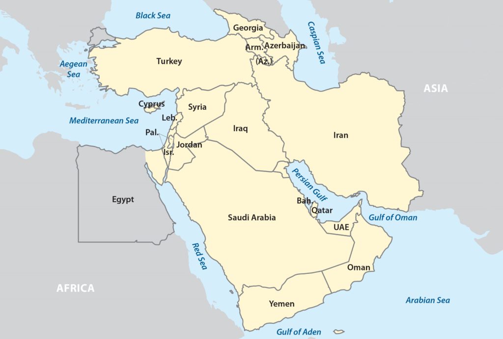 Figure 3. Map ofWestern Asia. Source: Wikipedia:https://upload.wikimedia.org/wikipedia/commons/thumb/1/1e/Western_Asia_2.png/550px-Western_Asia_2.png