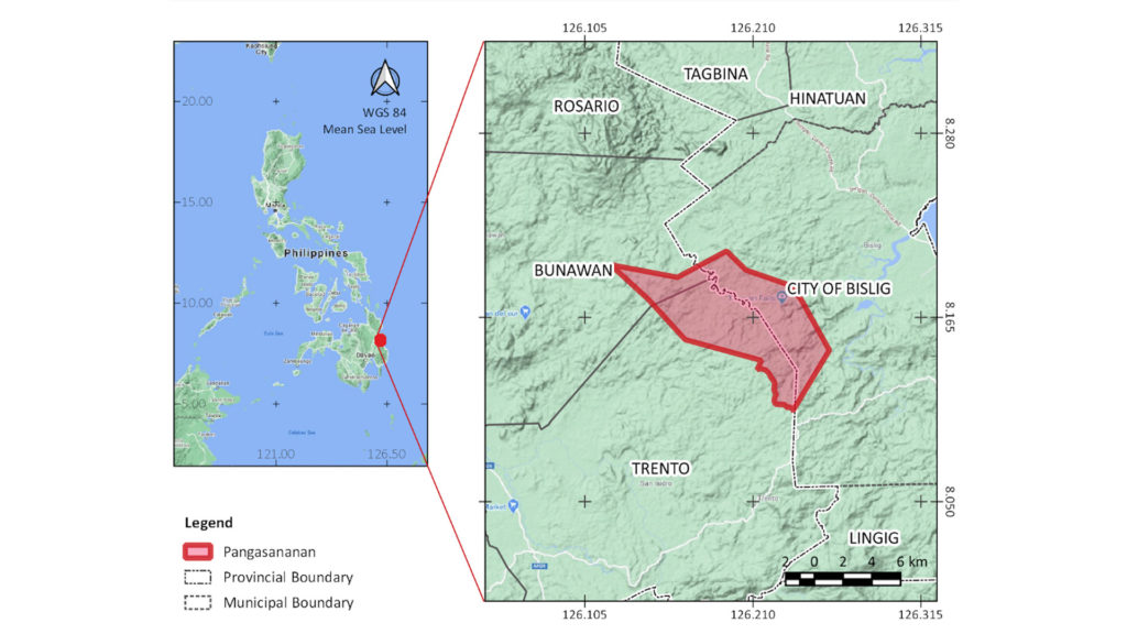
In the Philippines, an estimated 85 per cent of its remaining forests and 96 out of 128 of its key biodiversity areas overlap with Indigenous territories.[1] This is a strong indication that Indigenous peoples and their communities are central actors in protecting and conserving the Philippines’ remaining forests and in sustaining diverse life across the country. One such community is that of the Manobo in the villages of Sote and Baguis in the hinterlands of Bislig City, province of Surigao del Sur, island of Mindanao. This community calls their territory Pangasananan, which covers about 6,996 hectares.
Pangasanananis an old Manobo word that literally means a place where food, medicines and other needs are obtained. It is where the Manobo hunt wild game, collect honey, cultivate farms of fruits, vegetables, root crops, and upland rice, plant and grow pulp-wood trees, get fish and shellfish for a meal, gather herbs and spices for their dishes, and collect various plants and plant parts to cure illnesses of the body, mind and spirit. It provides them shelter and space to live and learn, a means to connect with the spirit world and their ancestors, a place for eternal repose and an inheritance to their children.
“If we abandon the territory, what will become of us? Nothing… we will perish and become nothing.”
Custodians: Manobo Indigenous peoples of Sote and Baguis, 1,500 residents
The Pangasananan and its Manobo custodians
The Manobo is the largest ethnolinguistic group in the Philippines. Its sub-groups are highly dispersed across Mindanao, each adapting to their environment and developing a localized version of the general Manobo culture. The custodians of the Pangasananan are a Manobo community of about 1,500 people who mainly rely on multi-cropped and intercropped cultivation of rice, corn, legume, root crops, vegetables, fruits and coconut in their kaingin or swidden farms. This is supplemented by hunting, fishing and gathering. Many also maintain abaca and pulp-wood trees in these farms. Some community members earn cash income as labourers and transporters. Despite being largely Christianized, the Manobo life remains governed by beliefs of the spirit world.
Aside from providing sustenance, the Pangasananan also serves as a sanctuary in times of crisis. During the Second World War, Manobo families hid in the forest to escape from Japanese invaders. Abundant food, herbal medicines and water ensured survival until the war ended. In 2020, the coronavirus (COVID-19) pandemic resulted in heavy-handed government lockdowns across the country, which affected their income-generating activities and compromised their safety. According to Archie Cortez, a young Manobo woman, if it weren’t for the Pangasananan, her family wouldn’t have had a safe space out of COVID-19’s reach. Hawudon Danao Virgilio Domogoy, a community leader, and his wife Victoria also shared their realization of how fortunate they are to have the Pangasananan because, despite losing some of their livelihoods, they were still able to survive on the crops in their farms, food from the forest and clean water from the creeks. Hawudon Sungkuan Nemesio Domogoy, another Manobo leader, said “This is what we gain from protecting our territory and its forests. All the difficulties paid off – the virus cannot harm us here [in the Pangasananan]. We survived the Japanese, PICOP company[2] and armed rebels. We will surely survive this pandemic.”
The Manobo believe that their continued existence as a people depends on the Pangasananan. For the Manobo, its destruction would mean the ultimate taboo: ingratitude and disrespect to the spirits and their ancestors, the obliteration of their indigenous identity, and turning their backs on the future of their children. Their chief Hawudon Tinuy-an Alfredo Domogoy once said, “If we abandon the territory, what will become of us? Nothing… we will perish and become nothing.”
“This is what we gain from protecting our territory and its forests. All the difficulties paid off – the virus cannot harm us here [in the Pangasananan]. We survived the Japanese, [the logging] company and armed rebels. We will surely survive this pandemic.”
Hawudon Sungkuan Nemesio Domogoy
Location of the Pangasananan in the Philippines and Mindanao. Map: Glaiza Tabanao (data sources see footnote 11)
Management and governance of the Pangasananan
The territory is divided into nine sectors called Kadumalahan. Each is headed by a Hawudon who is in charge of decision-making, conflict resolution and territorial security. Together, the Hawudon of each Kadumalahan form the council of leaders. This council convenes when the leaders need to discuss matters that affect the whole territory such as policy formulation and resolution of issues not resolved at the sectoral level. The Hawudon is helped by the Mala’as, Bagani and Baylan.
The Mala’as is a respected and influential elder in the community. They form the council of elders called Kamala’asan. They act as counsellors to the Hawudon and may influence the Hawudon’s decision but are not decision-makers themselves. The Bagani (warriors) help in the enforcement of policies, physical security and apprehension of illegal activities such as logging, poaching and migrant entry without consent. The Baylan (spiritual leader) does not partake in decision-making and enforcement of community laws. Their role is making sure that the community’s spiritual link is sustained. The conduct of rituals that require invoking powerful spirits for blessing, guidance and consent can only be facilitated by a Baylan.[3]
Through observation and with advice from leaders of other Indigenous communities and trusted partner organizations, the leaders have also adopted modern strategies to better manage the territory and its affairs. An example of this is the formation of the Manobo Tribal Council of Sote (MATRICOSO), which acts as a legal body tasked to manage business affairs and implementation of community development and conservation activities. MATRICOSO can also represent the community in negotiations and discussions with the government and other support groups. The community also forged an alliance with the Philippine military to help with territorial security and to provide some form of financial and other support to the Bagani (warriors).
Updating the 3-dimensional map with the current land uses in the territory. The map visualizes the Manobo’s knowledge of their territory and its physical features, identifying areas in need of reforestation or rehabilitation, and delineating areas for protection. Photo: Glaiza Tabanao
Ecological profile and biodiversity significance
The Manobo’s Pangasananan is 63 per cent forested, composed of old-growth and secondary forests, which hold approximately 470,755 tonnes of carbon in its woody trees.[4] Agroforestry areas, six small villages and several small to mid-sized multi-crop farms are also scattered across the territory. Caves and underground rivers abound.
A sacred lake called Danao floods the surrounding trees and caves during rainy season, creating a unique forest half-submerged in clean, cold water. The Danao is believed to be connected to a network of above- and under-ground rivers traversing through the territory making up the Tinuy-an Watershed. This watershed irrigates rice lands, farms and plantations and acts as an important water source for domestic use by the Manobo and the city downstream. It also hosts the Tinuy-an Falls, a famous tourist destination dubbed the “Little Niagara of the Philippines”. Before the pandemic, it attracted up to 160,000 visitors a year and contributed an average of PhP 8-11 million[5] earnings to the local government.
This mosaic of a landscape nurtured not only the Manobo but also the diverse and highly endemic life therein. In fact, the Pangasananan forms part of the Government-identified priority conservation site South Diwata key biodiversity area and the internationally renowned Bislig Important Bird and Biodiversity Area designated by Birdlife International.[6] This ecologically important area features endemic lowland dipterocarp forests dominated by Lithocarpus spp. and Shorea spp. According to BirdLife International, the Bislig Important Bird and Biodiversity Area hosts threatened and restricted-range bird species such as Mindanao Brown-dove, Mindanao bleeding-heart pigeon, spotted imperial pigeon, silvery kingfisher, rufous-lored kingfisher, wattled broadbill, azure-breasted pitta, Philippine leafbird, little slaty flycatcher, and celestial monarch. A variety of Philippine hawks and migratory birds are also seen in the territory. The Pangasananan forest is also a proven nesting and feeding ground for the critically endangered Philippine Eagle (Pithecophaga jefferyi).
Overlap of the Pangasananan and South Diwata KBA. Map: Glaiza Tabanao (data sources see footnote 11)
Overlap of the Pangasananan and Bislig IBA. Map: Glaiza Tabanao (data sources see footnote 11)
Overlap of the Pangasananan and the Tinuy-an Falls Protected Landscape. Map: Glaiza Tabanao (data sources see footnote 11)
Recognizing the area’s biodiversity significance, ecological functions and socio-economic importance, the Philippine Government, through its Department of Environment and Natural Resources (DENR), officially designated the Tinuy-an Falls and its entire watershed as a protected landscape[7] through Republic Act No. 11038 or the Expanded National Integrated Protected Areas System Act of 2018. The Tinuy-an Falls Protected Landscape overlaps with 3,163 hectares or roughly 45 per cent of the Pangasananan.
Effective community conservation
Nature in the Pangasananan remains rich and healthy because of a combination of traditional beliefs, Indigenous practices, strong defensive actions, innovative solutions and strategic partnerships. What started out as a means to survive daily life became a conscious effort to protect and conserve the environment to secure a better future.
The traditional belief that nature and its resources are managed and guarded by a host of spirits, whose favour must be won and wrath avoided, guides the Manobo in a respectful attitude towards their environment. Various rituals asking for permission to take from the bounty of nature (like hunting, fishing or obtaining honey), opening up the land for farming and entering sacred sites are conducted in reverence to the spirits and to ask for a bountiful hunt or harvest and safe passage. Through these rituals, the Manobo also ask for forgiveness in advance for any offense they might commit in the process. The Manobo also fear that if spirits are offended or displeased by their actions, it may result in a failed harvest, hunting accident, sickness, misfortune and sometimes even death, depending on the extent of wrongdoing or the spirit’s wrath.
Centuries of interdependence with their immediate environment has required them to develop practical, sensitive and essential conservation techniques that have sustained populations of traditionally important flora and fauna. Indigenous practices such as designating sanctuaries for wildlife, limiting or restricting entry into sacred areas, preserving key species of flora and fauna, designing hunting traps to avoid pregnant and young animals, designating off-season for hunting and limiting farm size indicate a conservation and protection approach to resource management. Harvesting timber also has certain restrictions based on their beliefs.
Aside from these practices, the Manobo have strongly defended and continue to defend the territory from large-scale commercial logging, small-scale illegal logging, armed rebel groups and forest clearing by migrant farmers. Most notable of these was their stand against the logging company Paper Industries Corporation of the Philippines, Inc. (PICOP). Around the 1990s, the company had almost entirely deforested the territory except for a few thousand hectares of old-growth forests. The Manobo families living in the forest were allegedly threatened and harassed by the company’s private army to make them leave by burning houses, destroying farms and criminalizing individuals. With nowhere to run and everything to lose, the young Manobo leaders and their patriarch founded the village of Sote on the road leading to their forest. When the bulldozers and armed men came, they gathered everyone using a taragong[8] and acted as human barricades. This effectively hindered the continuation of forest destruction in the area. To maintain vigilance on the territory boundaries and forest margins, the Manobo youth and their leaders organized themselves and regularly patrolled the territory. They established posts and camps in strategic locations to apprehend illegal entry and activities in the vicinity. Sure enough, they caught illegal loggers, seized their equipment and poached timber and turned them over to local officials.
The Manobo also forged strategic partnerships and alliances with groups and individuals who helped them strengthen traditional institutions, defend and secure legal ownership of the territory, provide livelihood assistance and establish networks and alliances. These include the local church, private armed groups, Armed Forces of the Philippines, various Philippine government agencies, migrant settlers with useful skills, Indigenous peoples’ organizations, local and international non-governmental or non-profit organizations, local government, and international funding agencies. It was through these partnerships that the community was able to apply innovative solutions, including a variety of participatory processes such as participatory research, 3-dimensional mapping of the territory, local resource inventory and community conservation planning.[9] They used all of these to finally get the government’s approval of the community’s claim of ownership over the territory after more than 10 years of trying to do so.
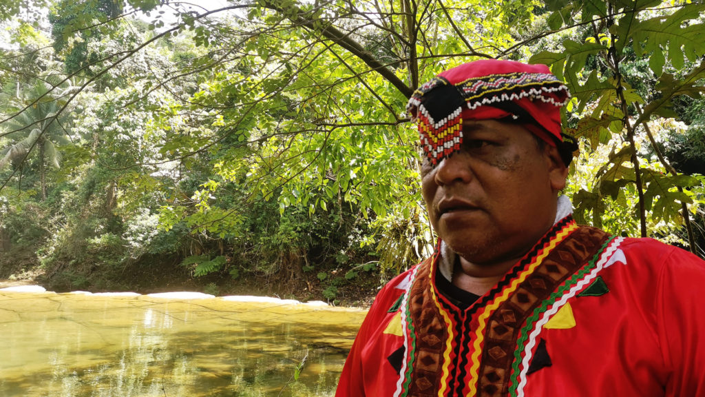
Hawudon Sungkuan Nemesio Dumogoy, Jr. in his traditional garb. He leads the Bagani in guarding the Pangasanan and its forests. The nesting site of the Philippine eagle is located in his Kadumalahan. Photo: Glaiza Tabanao
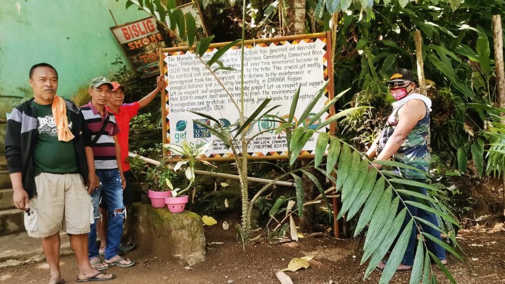
Manobo leaders showing the billboard they erected at the entrance of the Tinuy-an Falls eco-tourism park to inform guests that the place is part of their Pangasananan. This is part of the awareness campaign they launched with the help of the Philippine ICCA Project. Photo: Glaiza Tabanao
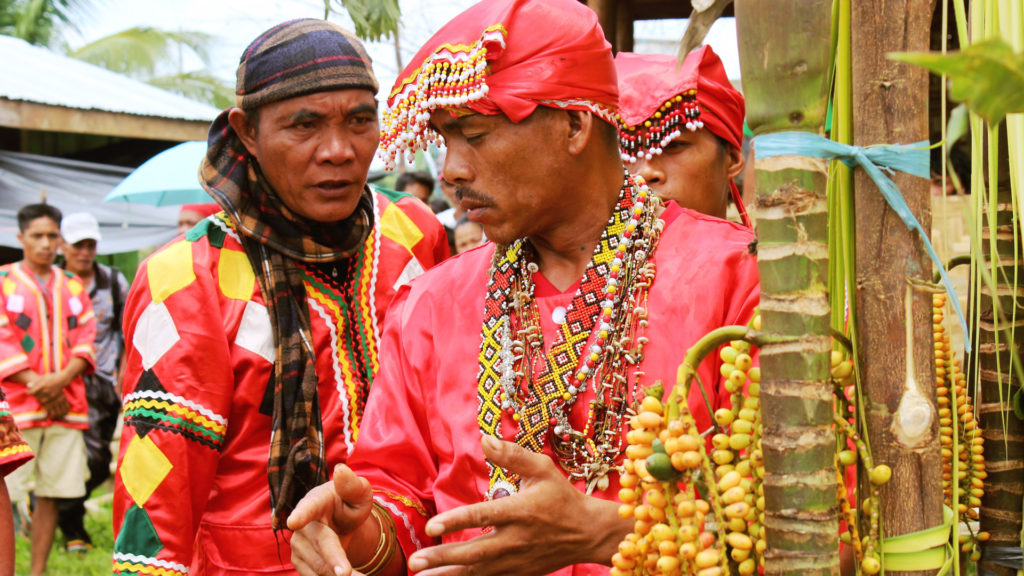
The Baylan (man in front), here possessed by a spirit, conversed with Hawudon Tinuy-an (man with brown head cover) during a ritual. Photo: Kim Reina Toyongan
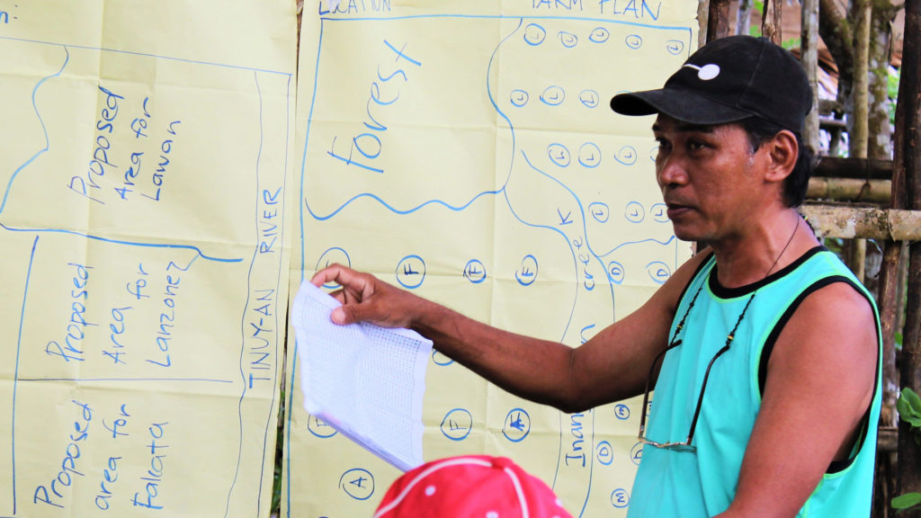
Hawudon Sayaw Rodino Domogoy during one of the farm planning sessions in the community. Photo: Ariane de los Angeles
Threats and challenges
Despite the community’s clear strength and resilience, it is still fraught with both external and internal issues that threaten the Pangasananan.
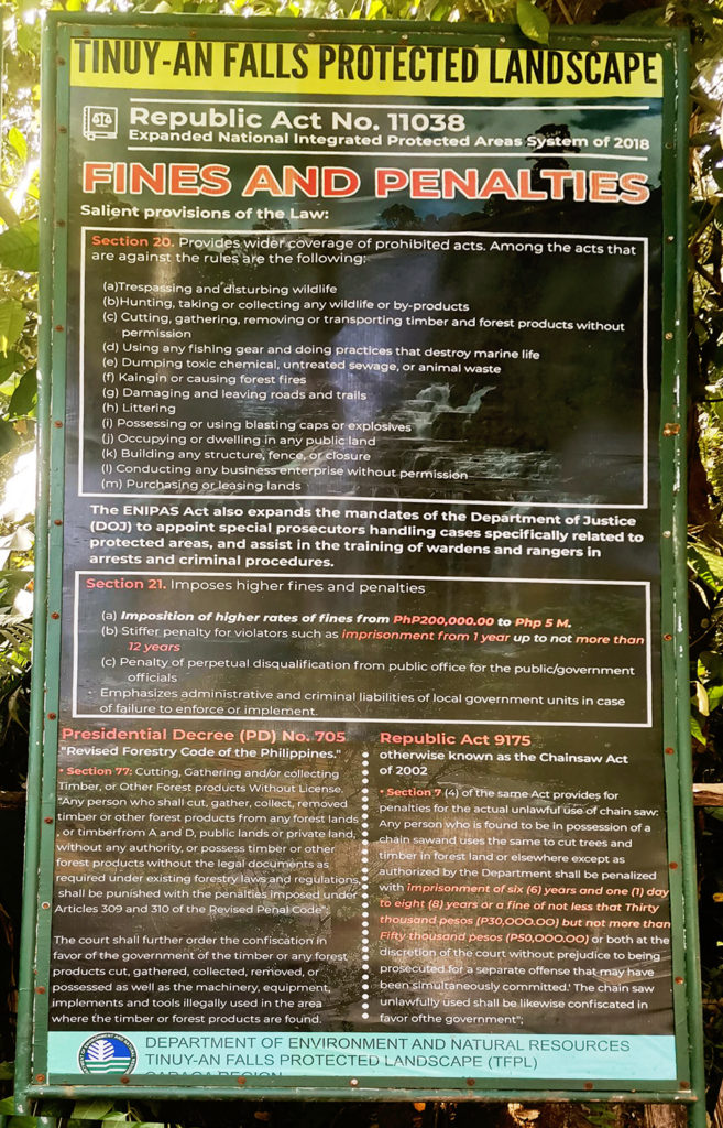
1. Significant overlap of a government protected area with the Pangasananan: The government-declared Tinuy-an Falls Protected Landscape, legislated via the Expanded National Integrated Protected Areas System Act of 2018, overlaps with 45 per cent of the Pangasananan. This should have been a cause for celebration as, in some ways, it recognizes the community’s conservation success and said law also supports recognition of traditional resource governance within protected areas. Funds will also be allocated by the government for the protection, rehabilitation, and conservation of the Protected Landscape. However, it is viewed by the community as problematic for several reasons explained below, namely: (a) they did not provide their free, prior and informed consent for its establishment; (b) it criminalizes the community for continuing their livelihood activities in areas overlapped by the protected area; and (c) it is undermining traditional governance.
No free, prior and informed consent: DENR went ahead with the Tinuy-an Falls Protected Landscape without proper coordination and consent from the community. After many instances when the DENR and Manobo leaders met and discussed the future of the Pangasananan and about how their traditions should be respected and their governance recognized, the community felt betrayed by this sudden announcement without prior information, consultation and coordination with the community. In February 2021, DENR conducted a communication, education and public awareness campaign in the community wherein they discussed the protected area’s objective, coverage and policies but once again did not seek consent. The Manobo leaders feel like the DENR is not keen on pursuing further steps in seeking their consent since the protected area activities continue despite not having a clear agreement with the community.
Criminalizing traditional resource use and management: When the Tinuy-an Falls Protected Landscape was enforced in 2019, traditional resource use and management was no longer allowed within it, despite the law saying they would be respected. This is a critical threat, as the areas overlapped by the protected area are the forests, hunting and fishing grounds and areas designated for agricultural use by the community. The DENR charged a Manobo with “illegal occupation” for maintaining a farm within the protected area. They then prepared an affidavit that says he is voluntarily vacating the lot within the protected area in admittance of his wrongdoing. The local DENR officer also allegedly told a Manobo that they are not allowed to obtain anything from the Tinuy-an Falls Protected Landscape, not even a blade of grass. A billboard erected by DENR near the entrance to Tinuy-an Falls Ecotourism Park essentially states that no one is allowed to use the resources inside the protected area. To this, Hawudon Danao, the best Manobo hunter in the Pangasananan, said “our farms and fallow areas are overlapped by the protected area. I hunt in the forests surrounding our farms. My son fishes in the creeks near our farms. Now that these are not allowed, how are we going to live? Where do they suppose we get our food and money for our needs?”
Traditional governance undermined: The Manobo successfully kept the natural environment relatively intact and healthy within the territory and this is mainly due to their steadfast governance and management of resource use in the area. They defended the territory with their lives. But now, they feel like this very success has jeopardized their hold on the Pangasananan because of the significant overlap of the protected area. Ever since the Tinuy-an Falls Protected Landscape was declared, DENR has filed charges against community members without coordinating with the traditional leaders, not giving the Manobo a chance to exercise their own governance processes. The Manobo are paraded in documents as members of the Protected Area Management Board but the Manobo feel the insincerity of this act. When the DENR and local government have activities, the Manobo are not consulted and their permission is not secured; they are just informed, as if they do not have the choice to say no or lay down their terms. The Manobo leaders lamented that the DENR only calls them when they need a guide in the forest. Hawudon Sayaw Rodino Domogoy further said, “According to the law, ‘The ICCAs and IPs concerned shall have the responsibility to govern, maintain, develop, protect such areas in accordance with their Indigenous Knowledge Systems and Practices (IKSP) and customary law, with the full and effective assistance from the NCIP, DENR, and other concerned Government Agencies’[10] Why does it feel like we are the assistants here? Why are our customary laws not respected? Why is it difficult for them to understand that we also have our own governance system? It seems like they are breaking the very law they created.”
2. Conflict with the Local Government: When the 2019 elections ushered in a new administration, the Manobo’s good relationship with the local government of Bislig City came crumbling down. The previous administration had forged a Memorandum of Agreement with MATRICOSO for the co-management of Tinuy-an Falls Ecotourism Park. This Memorandum of Agreement also ensured a 10 per cent share of the profits and accorded priority to Manobo community members for work in the ecotourism park. These were all put on hold when the new administration came in. A local government representative even threatened the Manobo leaders when they pushed for their right to be part of the management board. After two years of pushing, the local government finally allowed them to be part of the management board. According to the Manobo, however, this is just for show. They were there in paper, but they were not treated as decision-makers in reality and not even consulted regarding the local government’s planned developments and activities for the Tinuy-an Falls.
3. Weakening culture: Aside from external challenges, the community acknowledges that they are also contending with internal issues. They identified the need to strengthen their Manobo cultural traditions in order to prevent the loss of their unique identity and to ensure that present-day efforts will be continued by succeeding generations. Traditional arts, music and dances are not practiced anymore, especially now that the knowledge-holders are either too old or have already passed and the youth seem to be more interested in mainstream culture.
The welcome sign at the Tinuy-an Falls was erected by the City Government of Bislig. Photo: Glaiza Tabanao
The Tinuy-an Falls is a 3-tiered, 55-meter high, and 95-meter wide curtain of water surrounded by luscious forests, which has become a famous tourist destination. It received its name from a Manobo story about driving away a group of cruel slave traders that raided their territory centuries ago. Photo: Glaiza Tabanao
The DENR erected billboards in the Tinuy-an Falls eco-tourism park which list “prohibited acts”. Prohibitions include traditional livelihood activities by the Manobo such as kaingin, hunting, and dwelling in the government-declared protected area. Photo: Glaiza Tabanao
Hopes and dreams
Despite these challenges, the Manobo of Pangasananan hope to achieve a better life for their community and their children without sacrificing the integrity of their culture, nature and territory.
With the recent (2019) approval of their ancestral domain claim, the community hopes to strengthen themselves enough to better protect and develop their territory, as well as connect with suitable partners in implementing their self-determined development and conservation plans. Highlights of the community’s plans include reinforcement of riverbanks to minimize erosion and siltation; reforestation of denuded areas and water sources; strengthening of their Manobo culture; skills and capacity-building; financial, technical, and equipment support for the Bagani; provision of equipment for better monitoring of the Philippine Eagle and other important wildlife and the forest; and biodiversity-friendly projects that can support socio-economic needs such as potable water systems, livestock cultivation, fishponds and agroforestry development. They wanted to interface these plans with the local government’s comprehensive plans for the city’s development as well as with the Protected Area Management Plan for the Tinuy-an Falls Protected Landscape. They also wish to actively participate in the crafting of plans for the development of Tinuy-an Falls Ecotourism Park and reclaim their seat in the management board.
From these, it can be gleaned that the community does not wish to be isolated. They want to be seen and accorded respect for their traditional governance and resource use and management in their Pangasananan, especially by the government and its agencies. As Hawudon Sayaw expressed, they do not wish to oppose the government as they know that it could be their strongest and most sustainable ally; however, the only way their differences can be settled is if the government genuinely appreciates and supports their demonstrated commitment and internally driven efforts to conserve and protect the Pangasananan and the natural environment it cradles.
Cairns, M. 2000. “Ancestral Domain and National Park Protection: Mutually Supportive Paradigms?” Talamdan, 5(4).
Casiro, R. and Catubig, E. 2019. Paper Industries Corporation of the Philippines (PICOP): Its History and Socio- Economic Impact in Bislig City, Surigao Del Sur. International Conference on Public Organization.
De Vera, D. Lingating, R., Dagdag, J., Bordey, F., Reyes, G., Salomon, T., and Baguilat, T. 2019. A Critique on the Implementing Rules and Regulations of the Expanded National Integrated Protected Areas System Act and its Implications to the Rights of Indigenous Peoples. Quezon City: ANGOC, BUKLURAN, Inc., and PAFID, Inc.
Manobo Tribal Council of Sote and Philippine Association For Intercultural Development, Inc. 2019. Community Conservation Plan for the Pangasananan.
Manobo Tribal Council of Sote and Philippine Association For Intercultural Development, Inc. 2019. A Report on the Community Forest Resource Inventory of the Pangasananan.
Manobo Tribal Council of Sote and Philippine Association For Intercultural Development, Inc. 2011. Community Development Plan of the MATRICOSO.
Manobo Tribal Council of Sote and Philippine Association For Intercultural Development, Inc. 2011. Ancestral Domain Recognition Book of the Manobo Tribal Council of Sote.
Pedragosa, S. 2012. “Recognition and Support of ICCAs in the Philippines.” In: Kothari, A. with Corrigan, C., Jonas, H., Neumann, A., and Shrumm, H. (eds). Recognising and Supporting Territories and Areas Conserved By Indigenous Peoples And Local Communities: Global Overview and National Case Studies. Montreal, Canada: Secretariat of the Convention on Biological Diversity, ICCA Consortium, Kalpavriksh and Natural Justice.
Philippine Eagle Foundation, Conservation International-Philippines, Department of Environment and Natural Resources. 2008. Eastern Mindanao Biodiversity Corridor Conservation Framework. Davao City, Philippines.
[1] Analysis done by PAFID using data on key biodiversity areas from the Department of Environment and Natural Resources – Biodiversity Management Bureau and data on Indigenous territories from the National Commission on Indigenous Peoples.
[2] According to Casiro and Catubig (2019), Paper Industries Corporation of the Philippines, Inc. (PICOP) was the biggest and first wood-based company that operated a fully integrated pulp and paper mill in Southeast Asia in 1963. Its operation lasted for about 50 years. It is also said that PICOP was instrumental in the development of Bislig City’s economy.
[3] The Baylan is also a healer and has the most expansive knowledge on traditional medicines and healing rituals.
[4] Carbon stock obtained through a quantification study conducted by the Manobo community and PAFID in 2018.
[6] According to Birdlife International, the Bislig Important Bird and Biodiversity Area is a popular destination for birdwatchers from around the globe, “as it is one of the best places to see several scarce lowland forest birds.”
[7] The Philippine law describes a Protected Landscape as “an area of national significance, which is characterized by the harmonious interaction of man and land while providing opportunities for public enjoyment through recreation and tourism within the normal lifestyle and economic activity of the area.”
[8] Usually a piece of Indigenous musical instrument made of bamboo. A wooden or bamboo stick is used to strike the taragong and make a loud sound reminiscent of a toll bell.
[9] For more information on the processes undertaken, see this case study in the ICCA Consortium guidance.
[10] Portion of Section 13 of the Expanded National Integrated Protected Areas System Act of 2018.
[11] Map Data Sources: Manobo Participatory 3-Dimensional Community Mapping: Identification of Present Land Cover/Use, Landmarks, Traditional Use Areas, Roads/Trails and Rivers/Creeks on November 2017; Manobo & PAFID, GPS Survey of ancestral domain claim boundary corners from 27 March, 8 April and 2 July 2018; NAMRIA and PSA. Municipal boundaries of the Philippines (first quarter 2016). Publication Edition: 2016; CADT Boundary data from NCIP Region XIII, 2019; Base map from Google Terrain Hybrid; IBA shapefile from BirdLife International 2013. Country profile: Philippines. KBA shapefile from Conservation International, Department of Environment and Natural Resources-Protected Areas and Wildlife Bureau, Haribon Foundation. Priority Sites for Conservation: Key Biodiversity Areas.
About the authors
Glaiza Tabanao is a community development worker specializing in participatory research and mapping of Indigenous peoples’ territories in the Philippines. The Manobo community is the first she worked with when she joined the Philippine Association For Intercultural Development, Inc. (PAFID) in 2010. She has worked with Indigenous peoples ever since and is an Honorary member of the ICCA Consortium.


 Overlap of the Pangasananan and South Diwata KBA. Map: Glaiza Tabanao (data sources see footnote 11)
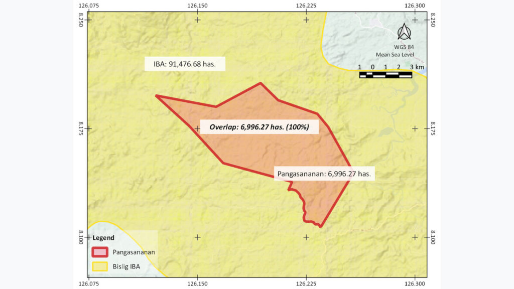 Overlap of the Pangasananan and Bislig IBA. Map: Glaiza Tabanao (data sources see footnote 11)
 Overlap of the Pangasananan and the Tinuy-an Falls Protected Landscape. Map: Glaiza Tabanao (data sources see footnote 11)