- Home
- Executive summary
- Territories
- Kisimbosa – DR Congo
- Yogbouo – Guinea
- Fokonolona of Tsiafajavona – Madagascar
- Kawawana – Senegal
- Lake Natron – Tanzania
- Qikiqtaaluk – Canada
- Sarayaku – Ecuador
- Komon Juyub – Guatemala
- Iña Wampisti Nunke – Peru
- Hkolo Tamutaku K’rer – Burma/Myanmar
- Fengshui forests of Qunan – China
- Adawal ki Devbani – India
- Tana’ ulen – Indonesia
- Chahdegal – Iran
- Tsum Valley – Nepal
- Pangasananan – Philippines
- Homórdkarácsonyfalva Közbirtokosság – Romania
- National and regional analyses
- Global analysis

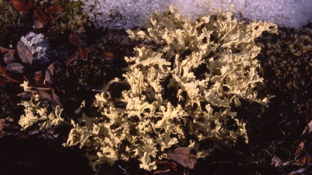
Three late Inuit elders, Abraham Etungat of Kinngait, Lucassie Nutaraluk of Iqaluit, and Etuangat Aksayuk of Pangnirtung, all told similar stories about tuktuit (caribou) from when they were young children living along different parts of the coast of Qikiqtaaluk (Baffin Island) in the 1910s and 1920s:
“When I was a young boy and tuktuit were always close by, I could not believe my elders when they told me that there would be no caribou when I would have to feed children of my own; but later when I became an elder myself, there would be many caribou again. They told the truth.”
As predicted by their elders, Abraham, Lucassie, Etuangat and many other Inuit experienced the scarcity of tuktuit on Qikiqtaaluk in the 1940s and 1950s as they tried to feed their young families. Later as elders themselves, they experienced the long-predicted abundance of tuktuit during the 1980s and 1990s. But then, being elders, they in turn predicted the next cyclical decline, which began in the late 1990s and early 2000s. The abundance has remained low into the late 2010s, but Inuit are reporting signs that the next slow recovery has began, again just as Inuit elders predicted.
“When I was a young boy and tuktuit were always close by, I could not believe my elders when they told me that there would be no caribou when I would have to feed children of my own; but later when I became an elder myself, there would be many caribou again. They told the truth.”
Inuit elders Abraham Etungat, Lucassie Nutaraluk and Etuangat Aksayuk
Photo: Michael Ferguson
18 Million hectares (proposed)

Custodians: 10 Inuit communities of Qikiqtaaluk
Inuit and their ancestors have harvested tuktuit on the interior of Qikiqtaaluk for at least 3,500 years.[1] Archaeologists have found ancient human habitation sites in important tuktuit habitats still known by Inuit elders today.[2] In Inuktitut (the language and culture of Inuit), Inuit can paint maps with words, having evolved in an environment lacking paper and pencils. During past decades when tuktuit were rare, as in the 1940s, Inuit travelled by dog sled to special places where, according to their elders, there could be some tuktuit when there were no tuktuit anywhere else. These harvesting journeys were extensive, moving up to 375 km inland and often lasting an entire year, so the harvesters could return with dried meat and skins for winter clothing for their extended families living on the coast. Sometimes they could not find tuktuit, but survived by catching small songbirds, like snow buntings, in summer. Some Inuit found starving by others would be escorted back to coastal communities where they would recover on seals, whales, fish and bears. Some never returned. The summer skins of tuktuit were critical to stay warm during the depths of winter. Speaking of the importance of tuktuit and their scarcity during the 1940s, the late Elijah Keenianak of Pangnirtung simply said:
“Everybody was cold. Nobody knew where the tuktuit were.”
Using Inuit Qaujimajatuqangit (Inuit traditional and recent knowledge), elders anticipate changes in the tuktuit population on Qikiqtaaluk, based on observed changes in distribution, movements, habitat selection and body condition. Inuit and their ancestors have been successfully monitoring and managing Qikiqtaaluk’s tuktuit for thousands of years.[3] In the early 1980s, Inuit elders predicted cyclical changes in the distributions of tuktuit on Qikiqtaaluk, which were then seen in the late 1980s and 1990s. More changes were seen by the early 2000s, leading harvesters and elders to anticipate the next major decline in the population from about 2006 to 2020, a period of scarcity similar to that of the 1940s and 1950s. Consequently, in 2004 to 2005, five communities on southern Qikiqtaaluk worked with the Nunavut government to develop a plan to manage tuktuit during this period of scarcity. However, the government failed to implement the plan.
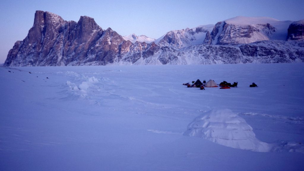
Qikiqtaaluk: its people and ecosystems
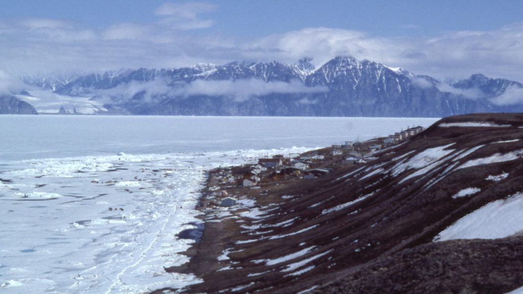
Qikiqtaaluk is the world’s fifth largest island with more than 507,000 sq km of Arctic tundra, ice caps, glaciers and lakes. It makes up about one-fourth of the Canadian territory of Nunavut, and forms part of the extensive circumpolar homelands of the Inuit. With a culture and technologies adapted for life on Arctic tundra and waters, the ancestors of the Inuit expanded their range perhaps 4,000 years ago from the northeastern edges of Asia eastward across the tundra ecosystems of North America. Inuit probably reached eastern Greenland about 800 years ago. The human population of Nunavut was about 30,100 (85% Inuit) in 2016. Inuit who have traditionally depended on Qikiqtaaluk’s tuktuit live in 10 communities on or near the coasts of Qikiqtaaluk. In 2016, these 10 communities had a total population of 18,378 people, 14,335 being Inuit (78%).[4]
Despite increasing outside influences from the south, Inuit traditions and cultural values for tuktuit and other wildlife remain important and largely intact. In Nunavut, the taking of wildlife by Inuit for subsistence food and cultural uses is called “harvesting”. Harvesting of wildlife in Nunavut and other Arctic regions continues to be important for food sovereignty and daily nutrition of Inuit.[5] Among Inuit of Qikiqtaaluk and other regions, successful harvesters who can feed their families and others in their communities are highly respected.
Monetary employment remains very limited in most communities (with some wages from government, retail, transportation, tourism, crafts and related sectors). An underground lead-zinc mine had been active on northern Qikiqtaaluk from 1976 to 2002 but provided economic benefits to few Inuit. In 2015, Baffinland opened an open-pit iron-ore mine on northern Qikiqtaaluk. The Qikiqtaaluk Wildlife Board (QWB) and local Hunters and Trappers Organizations (HTOs) have concerns about current and future impacts of this mine on tuktuit and important marine mammals like narwhal. Inuit have seen negative impacts of the iron mining on tuktuit, narwhal and other wildlife, but Baffinland has not acknowledge these impacts. Currently, the mine ships 6 million tonnes of ore to Europe annually, and proposes to expand production to 12 million tonnes, which will probably financially enable development of a previously approved railroad and port for an additional 18 million tonnes annually, for a total of 500% of recent production.[6],[7] In addition, extensive exploration for diamonds,[8] gold[9] and other minerals are on-going on Qikiqtaaluk.

Qikiqtaaluk holds diverse landscapes and ecosystems, home to many Arctic animal species. Baffin Bay and Davis Strait off the eastern coast hold important populations of polar bears, seals, narwhal, bowhead whales, beluga, seabirds and eiders, all important food and cultural resources for Inuit.
Eastern Qikiqtaaluk has a 1,650-km-long mountainous spine with deep fiords and glaciers, including the Barnes Ice Cap; this last remnant North American Glaciation with ice over 20,000 years old has started to melt rapidly in recent years.[10] Today, this mountain range impacts the climate of Qikiqtaaluk as weather systems from the west shed moisture across rising elevations, with drier, windier and cooler air over the eastern mountains. Ancient ice caps and glaciers continue to influence vegetation growth and habitat patterns for tuktuit, especially their rootless lichen winter forage. Inuit recognize different types of tuktuit that have adapted to the mountains and high plateaus of eastern Qikiqtaaluk; their physical structure and migratory behaviours differ from tuktuit that utilize lower elevations.
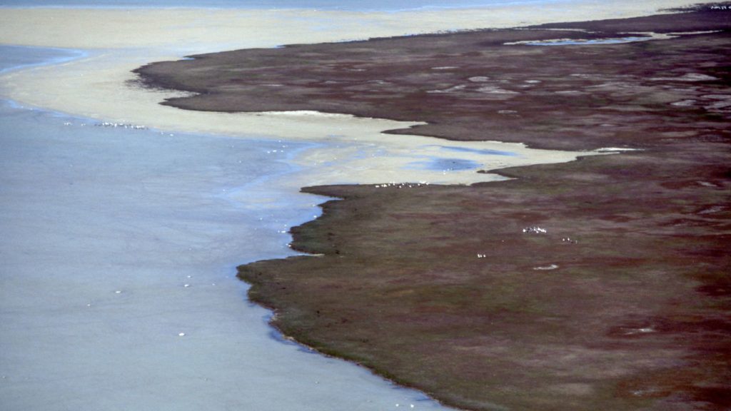
The western landscape of Qikiqtaaluk is the complete opposite to the eastern mountains. The Great Plain of the Koukdjuak (Kuujjuaq), with the world’s largest goose colony (15,775 sq km), is a massive flat wetland lying along Foxe Basin. The Foxe Basin lowlands extend both north and south of the Great Plain over a distance of more than 1,000 km. Besides many other waterfowl, terns, gulls and shorebirds, about 1.75 million snow geese, 33 per cent of the world’s population, breed on the Great Plain. The waters of Foxe Basin are home to Qikiqtaaluk’s largest aiviq (walrus) population, besides many other marine mammals and birds The Great Plain and all the coastal wetlands around Foxe Basin are important post-calving habitats for tuktuit with lush sedges, grasses and other plants during summer, but their winter forage is not accessible here during winter due to the hard, unbroken wind-blown snow cover.
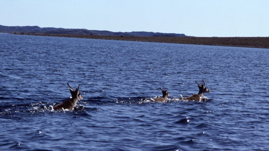
In addition to the Barnes Ice Cap lying between the lowlands around Foxe Basin and Qikiqtaaluk’s eastern mountains, the world’s largest lake on an island, Natsilik (Nettilling Lake), covers some 5,540 sq km.[11] To the south lies another large lake, Ammaqjuaq (Amadjuak Lake; 3,115 sq km). Its watershed flows into Natsilik and then west down Kuujjuaq (Koukdjuak River) into Foxe Basin, forming a unique low-Arctic bioclimatic zone. Climatically stable for 4,800 years, this low-Arctic zone is more biologically diverse than the surrounding high Arctic zone of Qikiqtaaluk.[12] In the 1970s and 1980s, thousands of migratory Natsilik tuktuit swam south across Kuujjuaq and the eastern side of Natsilik during July, August and early September en route to their rutting and wintering areas.

The Nunavut Agreement and the Qikiqtaaluk Wildlife Board
After about 20 years of negotiation, in 1993 the Inuit of Nunavut signed the Nunavut Agreement[13] with the Crown of Canada. The Agreement is second only to Canada’s Constitution, so that no government act or policy may infringe on the rights granted to Inuit. In this Agreement, the Inuit are represented collectively by Nunavut Tunngavik Incorporated, while the Crown is represented by the governments of Canada and Nunavut. The agreement was designed to meet the following objectives:
- to provide for certainty and clarity of rights to ownership and use of lands and resources, and of rights for Inuit to participate in decision-making concerning the use, management and conservation of land, water and resources, including offshore;
- to provide Inuit with wildlife harvesting rights (throughout Nunavut) and rights to participate in decision-making concerning wildlife harvesting;
- to provide Inuit with financial compensation and means of participating in economic opportunities; and
- to encourage self-reliance and the cultural and social well-being of Inuit.
The Agreement provided for the establishment of several boards and commissions as instruments of public government to promote continued dialogue between government and Inuit. Ultimate responsibility for decisions was given to government ministers. Three boards and commissions are key players in environmental, wildlife and land use planning issues: the Nunavut Wildlife Management Board, the Nunavut Planning Commission, and the Nunavut Impact Review Board.
Inuit have representation equal to government on these boards and commissions, with independent chairpersons. Although government ministers have the ultimate responsibility on specific decisions made by the boards and commissions, disagreements are usually resolved through negotiations, although in some cases Nunavut Tunngavik Incorporated has taken the governments to court to defend Inuit rights. For the first time in 2021, the Qikiqtaaluk Wildlife Board filed a court case against the Government of Nunavut, which was subsequently settled out of court.
The Qikiqtaaluk Wildlife Board (QWB) is an Inuit Regional Wildlife Organization, recognized under the agreement. The QWB participates in co-management of wildlife and land use planning across the entire Qikiqtaaluk Region.[14] The QWB has an independent chairperson and 13 directors who are also the chairpersons of the region’s 13 Hunter and Trapper Organizations (HTOs). Each HTO represents all Inuit in one of the 13 communities. QWB works closely with the 13 HTOs to represent their interests at meetings of the co-management commissions and boards. The QWB also works with its co-management partners in the federal and territorial governments, and with some environmental NGOs. The QWB has specific and general powers and functions to manage wildlife harvesting among any two or more of the region’s HTOs. The QWB’s responsibilities apply to most populations of wildlife because most are shared by more than one community. Each HTO is responsible for managing the harvesting by Inuit within its given community.
The QWB also works with another regional Inuit organization, the Qikiqtani Inuit Association (QIA), which is mandated to protect and promote Inuit social, political, economic and cultural interests. The QIA manages the approximately 35 per cent of the region’s land for which Inuit own surface rights and the 3.5 per cent for which Inuit own sub-surface rights. QIA is also responsible for negotiating Inuit Impacts and Benefits Agreements with governments, mining and other developers for proposed projects on all regional lands and waters.

The QWB’s and HTOs’ Submissions to the Nunavut Planning Commission
In Qikiqtaaluk, some wildlife habitats are formally protected in two national parks covering about 8 per cent of the island (41,300 sq km); however, a large proportion of these parks includes ice caps and glaciers, and little habitat for tuktuit. There are two territorial parks and one proposed park on Qikiqtaaluk. Currently, the largest territorial park covers about 1,260 sq km. Three calving areas, used by migratory Natsilik tuktuit, are recognized in the regulations of Nunavut’s Wildlife Act; however, there are no regulations for habitat protection. Gold exploration is currently occurring within one of these calving areas.[15]
Although the Government of Nunavut has powers to protect important habitats of tuktuit on Qikiqtaaluk, it has not done so. Habitat protection was proposed in the tuktuit management plan developed in 2005. The Government of Nunavut now appears to oppose any long-term or permanent protection of important habitats for tuktuit and other wildlife.
The 2016 draft Nunavut Land Use Plan did not identify any protected or special management areas specifically for tuktuit on Qikiqtaaluk. During 2017-18, the QWB and HTOs identified many important wildlife areas that should be protected from future non-traditional development. These areas are needed by Inuit for food security and sovereignty, and have been used by Inuit for 1,000s of years. This QWB-HTO project resulted in 43 written submissions to the Nunavut Planning Commission (NPC) for areas to be protected under the future Nunavut Land Use Plan.[16] Five of these submissions cover different types of habitats important mainly for tuktuit-related values; each submission may identify one or more specific areas. Through these submissions to NPC, the QWB and HTOs have proposed protection for tuktuit across 180,200 sq km (18 Million ha) of Qikiqtaaluk, plus 417 sq km (41,700 ha) of sea-ice crossings in the fiords (see figure 2). Many of these areas could potentially be identified as formal ICCAs or “Inuit territories of life”.

Given the inaction of the Government of Nunavut to protect tuktuit on Qikiqtaaluk in the past, the QWB hopes to build consensus with other partners that may be more inclined to protect Inuit food and cultural sovereignty. Both the Nunavut Wildlife Management Board and the Qikiqtani Inuit Association have taken positions advocating the protection of at least calving areas for tuktuit. The QWB hopes to work through the Nunavut Planning Commission to influence the future Nunavut Land Use Plan. The QWB is considering self-declaration and registration of several tuktuit and other wildlife conservation areas in the ICCA Registry of the UNEP World Conservation Monitoring Centre to promote recognition of Inuit efforts at the international level.
Inuit consensus building
Before the 1970s and 1980s, most Inuit lived in many small, scattered family areas, often moving seasonally to access wildlife and for other reasons. Inuit used and travelled across all of Qikiqtaaluk. Sometimes several family groups would come together for various purposes and events. To maintain cohesion and cooperation for collective benefit, Inuit social behaviours followed norms that promoted consensus building. Usually elders listened carefully, as other Inuit discussed important issues openly. When the time was right, respected elders would offer a solution that would benefit the entire group.
The QWB and most Inuit organizations continue to follow traditional norms for consensus building. When it comes time to take a vote for the record, it is usually unanimous. If unanimity appears unlikely, then a vote may not be called. In such cases, the best solution would require more discussion, thought and time.
Unfortunately, when working with governments, Inuit norms of behaviour may not be compatible with those of government and other participants, leading others to dominate decision-making while undermining consensus building.
Often at cross-cultural meetings, a tendency can be observed in which a biologist or government manager speaks strongly and appears closed to information or options based on Inuit Qaujimajatuqangit (IQ, or knowledge). Knowledgeable Inuit may ask non-Inuit if they know about a specific topic, non-confrontational questions that can be subtle invitations for others to seek new information or options from Inuit, instead of apparently continuing discounting Inuit knowledge and views. Some non-Inuit may argue about wildlife or the environment, which makes elders and other Inuit uncomfortable. Such foreign behaviours may undermine consensus building with Inuit. As a result, important Inuit knowledge, views, solutions and wisdom may not be expressed. Silence and lack of disagreement by Inuit in such situations does not indicate agreement. Efforts at finding consensus are also hampered because government ministers retain ultimate responsibility in Nunavut and usually disregard alternatives based on IQ.

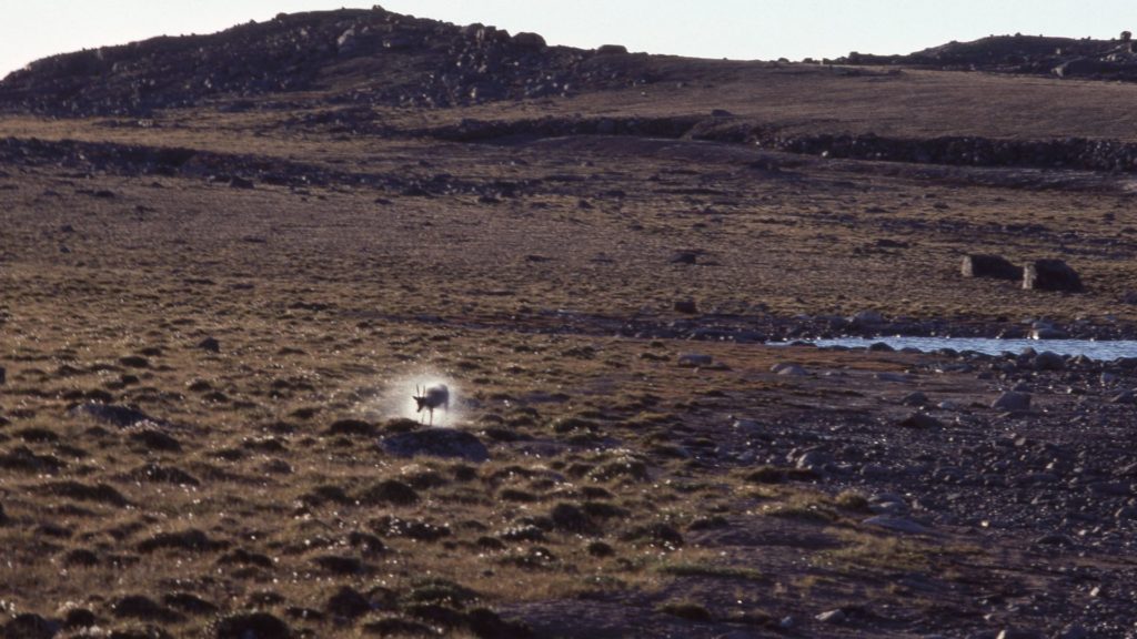
Tuktuit, biodiversity, climate change and development
Inuit Qaujimajatuqangit teaches that the population cycle of tuktuit on Qikiqtaaluk lasts the lifetime of an elder, 70 to 90 years.[17] Inuit elders can predict the phases of this cycle and the abundance of tuktuit through on-going monitoring by Inuit harvesters, without need for expensive surveys. Most Inuit do not believe in the accuracy of scientific wildlife surveys. The truth of IQ has been proven for generations, and it is always being updated, verified and revised if needed by active harvesters and elders working together.
When tuktuit are at high density on Qikiqtaaluk, they change entire plant communities within their wintering habitats.[18] During winter, tuktuit eat mainly lichen for energy if adequately abundant. While digging through snow to access lichen, they break and dislodge shrubs, herbs, grasses, other plants and soil, which may then blow away in the wind into depressions and streams. If tuktuit did not reach high densities for a full cycle, vascular plants could eventually dominate the tundra of Qikiqtaaluk, and those plants would shade out and reduce future growth of the lichen that tuktuit need in winter. Over the long term, the loss of plant biodiversity caused by high densities of tuktuit is needed so that lichens, tuktuit and Inuit can flourish during some phases of these long population cycles.
Some Inuit elders have stated that after there have been too many tuktuit for too long, it can take 30 years for their food, the lichen, to recover. Once there’s been sufficient time, tuktuit immigrate from other areas and gradually increase to become abundant again. Other elders pointed to signs that they see on the land itself, as the late Geosha Uniuqsaraq of Iqaluit explained in the early 1990s, “my elders told me that tuktuit will return when old antlers become covered with lichens. That was how I knew they would return.”
On the other hand, abundant tuktuit cannot be found in all parts of Qikiqtaaluk at the same time. As elders had predicted in the 1980s, after tuktuit had wintered on Foxe Peninsula for about 20 years, they emigrated en masse, shifting their winter range eastward by about 375 km to occupy a little grazed area on Meta Incognita Peninsula.[19] Tuktuit that remained on Foxe Peninsula into the 1990s were in very poor condition and eventually left that area, too. Tuktuit that moved to Meta Incognita Peninsula became fat, were more productive, and could dig through much harder and deeper snow because the lichens under the snow were abundant. As stated by several elders, “snow is no problem for tuktuit unless there has been too many tuktuit for too long.”
The complexity of these interactions makes it difficult to make predictions about the impacts of climate change on tuktuit or other wildlife. Tuktuit may adapt readily to climate change resulting in deeper snow, more wind or even rain/ice on snow in autumn, where populations have been low. But there are places on Qikiqtaauk where there have been too many tuktuit in recent decades, so climate change could be devastating if, as elders say, the land cannot rest. Tuktuit may leave those places and survive if they can find areas with better snow conditions or more lichens, or they may not.

Inuit elders understand that when tuktuit are abundant and in good physical condition, they go where they want, as they once did on Qikiqtaaluk in the 1980s and 1990s. However, when there are only a few tuktuit or when they are in poor condition, they are very sensitive to human disturbance and new infrastructure on the land. Females with calves are often most sensitive, but in some areas and seasons males may also be sensitive. On the other hand, malnourished tuktuit may seem undisturbed by humans and not immediately try to escape, but they may not return to such areas. When there are few tuktuit, development such as mining, roads and wind turbines can put the recovery of a small population at risk, especially if their habitats are not protected over the long term. However, at cross-cultural meetings, developers may argue that there just are not many tuktuit in the first place, and therefore they argue that it is pointless to protect the area in question. Such difficult discussions are underway on northern Qikiqtaaluk regarding the Baffinland iron mine and their proposals to increase production and develop a railroad.
As the responses of tuktuit may be delayed and varied depending on forage resources, population density, seasonality, sex and age, physical condition and various environmental conditions, impacts of disturbance and development is difficult to detect using scientific methods. Knowledgeable Inuit often make different conclusions from governments, biologists and developers about the impacts of development and climate change because they have deeper, more nuanced understandings and appreciations of tuktuit and other Arctic wildlife.
Tuktuit and Inuit
Even during periods of cyclical scarcity, harvesting tuktuit gives great pride among Inuit. It ties entire communities together, and helps to ensure the transfer of Inuit Qaujimajatuqangit about tuktuit, weather, climate, the land, plants and other animals to younger generations. As expressed by the late Pauloosie Kilabuk of Iqaluit in the late 1980s:
“I hunt for other people. I go out and get a caribou … It keeps me close to the men I hunt with. I make my parents, kids, relatives and friends happy because they don’t have caribou sometimes, and we all come together and share the meat. Caribou is more important than seal to keep my family and community together. … What is a community feast without caribou?”[20]
From 1980 to 1984, the Qikiqtani Inuit Association’s predecessor conducted the first Inuit harvesting study in the region.[21] During those years, they estimated that Inuit harvested 12,000 to 16,000 tuktuit annually from Qikiqtaaluk, and all signs indicated that the population was still growing. At that time, it would have cost about 11 million Canadian dollars annually to replace that resource with beef from southern Canada.
From 1997 to 2001, the Nunavut Wildlife Management Board[22] conducted another harvest study and estimated that Inuit harvested fewer tuktuit, 8,000 to 11,000 annually from Qikiqtaaluk. These were the years when Inuit hunters first reported changes that elders read as signs of potential future scarcity of tuktuit on Qikiqtaaluk; this is likely when the decline phase of the 70 to 90-year population cycle started.

“I hunt for other people. I go out and get a caribou … It keeps me close to the men I hunt with. I make my parents, kids, relatives and friends happy because they don’t have caribou sometimes, and we all come together and share the meat. Caribou is more important than seal to keep my family and community together. … What is a community feast without caribou?”
The QWB and local HTOs warned the government about the serious changes predicted by Inuit elders, and requested development of a long-term management plan based on Inuit Qaujimajatuqangit. A 15-year management plan was developed for southern Qikiqtaaluk tuktuit during workshops in 2004 and 2005, held by the Government of Nunavut, the QWB and HTOs. The plan was presented to the Nunavut Wildlife Management Board for review in 2005.The QWB and HTOs requested similar planning workshops for similar changes and Inuit predictions for tuktuit on northern Qikiqtaaluk. Unfortunately, the government did not hold the requested northern Qikiqtaaluk workshops and did not implement the management and research actions requested by the QWB and HTOs in the southern Qikiqtaaluk plan.
When the predicted declines could no longer be ignored, in 2014 the government conducted an ambitious aerial survey of the entire island and nearby lands to produce a population estimate of 4,650 tuktuit (95% CI: 3,460 – 6,250).[23] Although the QWB agreed that the population had declined and was at a low point in its cycle, the QWB did not agree with the specific 2014 population estimate or the subsequent management actions undertaken by the government.[24] Initially, the Government of Nunavut imposed a harvesting moratorium, but after about six months, changed that to a Total Allowable Harvest of 250 males in 2015.
In 2020, the QWB applied to the Nunavut Wildlife Management Board to increase the Total Allowable Harvest to 325 and allow the harvest of 45 females. Inuit elders advise against the harvest of only one sex because it may upset the balance of the sexes within the social system of tuktuit sub-populations. These requests were based largely on Inuit Qaujimajatuqangit which has been shown to be accurate and predictive over the past 40 years, and for generations before. These applications were consistently opposed by the Government of Nunavut and denied by the Nunavut Wildlife Management Board, although the harvest of up to 25 females has been permitted since 2019.
Based on IQ and harvesters’ observations as they continue to monitor changing distributions of tuktuit, just as Inuit have always done, the QWB understands that the population of tuktuit on Qikiqtaaluk is growing and can support more harvesting. For example, tuktuit are returning to Foxe Peninsula and other areas in winter, where they had been absent during winter for about 30 years. To prove the point, the QWB has raised funding to formally document IQ, hunter observations and collect fecal genetic samples in three communities during 2021-22.

In the 1940s and 1950s after the previous cyclical decline, Inuit reported that they had to keep harvesting tuktuit even though they were low in abundance. This was for two main reasons: (1) to obtain food and winter clothing, and (2) to “let the land rest” so that continued harvesting would restore the ecological balance between tuktuit and their slow-growing winter lichen forage after too many tuktuit for too long. Tuktuit populations can increase rapidly after sufficient lichen forage accumulates; however, without sufficient harvesting for perhaps a decade or longer after a cyclical decline, their potential for rapid population growth could potentially maintain their winter forage in a perpetually over-grazed state, and the major increase phase of their cycles may never return.
Biologists with the Government of Nunavut have advocated management to maximize current population growth, while stating they do not know why the decline occurred in the first place. Through their ancient knowledge and on-going year-round monitoring of Qikiqtaaluk tuktuit, Inuit accurately predicted the decline, they know why it occurred, and they know how to manage the recovery of tuktuit for future generations of tuktuit and Inuit, and the lichen resources that they all depend upon.
The QWB plans to apply again to the Nunavut Wildlife Management Board in 2021-22 for an increase in the Total Allowable Harvest. Even though government ministers retain ultimate authority, the QWB will continue to promote the recovery, protection and management of Qikiqtaaluk tuktuit and their habitats based on the values, principles and teachings of Inuit Qaujimajatuqangit. In fact, in late 2020 the QWB Executive decided to assert the primacy of Inuit systems of wildlife management as a constitutionally protected Indigenous right in Nunavut.

[1] Milne, S.B., R.W. Park and D.R. Stenton. 2012. Dorset culture land use strategies and the case of inland southern Baffin Island. Canadian Journal of Archaeology 36: 267–288.
[2] Park, R.W., S.B. Milne and D.R. Stenton. 2017. Burin and spall use at an inland arctic small tool tradition site, southern Baffin Island, Nunavut. Canadian Journal of Archaeology 41:63–78.
[3] Ferguson, M.A.D., and Messier, F. 1997. Collection and analysis of traditional ecological knowledge about a population of arctic tundra caribou. Arctic 50: 17–28.
[4] Based on 2011 census result with estimates projected to 2016 (Nunavut Bureau of Statistics 2016). The communities have young and growing populations, typical of many Indigenous peoples; 48% of the population is 24 years old or less, and only 7% are 65 or older.
[5] Imported foods are extremely expensive, and 70% of preschool Inuit children live in food insecure homes.
[6] https://www.cbc.ca/news/canada/north/mine-blockade-sparks-solidarity-protests-across-nunavut-1.5906285
[7] https://www.cbc.ca/news/canada/north/nirb-baffinland-hearings-suspended-covid-1.5988416
[8] https://nunatsiaq.com/stories/article/de-beers-dreams-of-building-the-diamond-mine-of-the-future-in-nunavut/
[9] https://www.mining.com/kivalliq-picks-baffin-island-gold-property-previously-explored-three-majors/
[10] https://eos.org/scientific-press/last-remnant-of-north-american-ice-sheet-to-vanish-in-300-years
[11] Inuit named Natsilik after natsiq (ringed seal) because this usually marine seal and important food source of both Inuit and polar bears lives in this lake year-round.
[12] Jacobs, J.D., A.N. Headley, L.A. Maus, W.N. Mode and É.L. Simms. 1997. Climate and vegetation of the interior lowlands of southern Baffin Island: Long-term stability at the low arctic limit. Arctic 50: 167– 177.
[13] https://nlca.tunngavik.com/
[14] Being about one half of Nunavut, the Qikiqtaaluk Region covers the entire Qikiqtaaluk (Baffin Island) of around 500,000 sq km plus many other islands and some of mainland Nunavut for about an additional 500,000 sq km. https://en.wikipedia.org/wiki/File:Map_of_the_Nunavut_regions.png
[15] https://www.gov.nu.ca/sites/default/files/exploration_overview_2020-english.pdf
[16] The most recent 2016 draft of the Nunavut Land Use Plan has not been approved: https://www.nunavut.ca/land-use-plans/draft-nunavut-land-use-plan. The next draft of the Nunavut Land Use Plan was not made available in 2020 as suggested by the Commission’s Executive Director in 2019. It may become available by 2022 as suggested by the Commission’s Policy and Planning Director at the Nunavut Mining Symposium in 2018.
[17] Ferguson, M.A.D., R.G. Williamson and F. Messier. 1998. Inuit knowledge of long-term changes in a population of arctic tundra caribou. Arctic 51: 201–219.
[18] Ferguson, M.A.D., L. Gauthier, and F. Messier. 2001. Range shift and winter foraging ecology of a population of Arctic tundra caribou. Canadian Journal of Zoology 79: 746–758.
[19] Ferguson, M.A.D., and Messier, F. 2000. Mass emigration of arctic tundra caribou from a traditional winter range: population dynamics and physical condition. Journal of Wildlife Management 64: 168–178.
[20] Ferguson, M.A.D. 1989. Baffin Island. In People and caribou in the Northwest Territories. Edited by E. Hall. Department of Renewable Resources, Government of the Northwest Territories, Yellowknife. pp. 141–149
[21] Donaldson, J.L. 1988. The economic ecology of hunting: A case study of the Canadian Inuit. Ph.D. dissertation, Department of Biology, Harvard University, USA.
[22] Prest, H. and P.J. Usher. 2004. The Nunavut wildlife harvest study: Final report. The Nunavut Wildlife Management Board, Iqaluit, NU.
[23] Campbell, M., J. Goorts, D.S. Lee, J. Boulanger and T. Pretzlaw. 2015. Aerial abundance estimates, seasonal range use, and spatial affiliations of the barren-ground caribou (Rangifer tarandus groenlandicus) on Baffin Island – March 2014. Technical Report Series No: 01-2015, Department of Environment, Government of Nunavut.
[24] Several QWB submissions have been made to the Nunavut Wildlife Management Board beginning the following one in February 2015: https://www.nwmb.com/en/public-hearings-a-meetings/public-hearings-1/2015-2/public-hearing-concerning-baffin-island-caribou-harvest-management/submissions-4/5106-qikiqtaaluk-wildlife-board-submission-bic-february-13-2015-eng/file