Author(s): Saw Paul Sein Twa, Julia Fogerite, Casper Palmano
Publication date: 10 March, 2021
This article was written before the illegal seizure of power by the Myanmar military on 1 February 2021. For the recent developments, refer to the update at the bottom of the page.
The Salween Peace Park was founded by the Indigenous Karen people of Mutraw District, Kawthoolei, Burma/Myanmar, to protect and bring peace to this bastion of biodiversity and Karen culture after over 70 years of conflict. The Park is a result of grassroots efforts by the Karen people living in 348 villages within it to practice democracy and self-determination, protect themselves and the environment from destructive investment, and develop their own vision for a just, peaceful, and sustainable future.
The Salween Peace Park (Hkolo Tamutaku K’rer in Karen language) was formally declared in December 2018, after a referendum approved its Charter with signatures from over 75 per cent of the 67,800 voting-age people living within its area. The Charter established the principles and governance of the Peace Park, with Kaw common territories managed with Karen customary laws and practices at its heart (KESAN 2019a).
“We, the Indigenous Karen people of Mutraw, […] in order to create and sustain a lasting peace in our lands, protect and maintain the environmental integrity of the Salween river basin, preserve our unique cultural heritage, and further the self-determination of our people; do enact and establish the Salween Peace Park.”
Declaration of the establishment of the Salween Peace Park, on 19 December 2018 in Day Bu Noh Village, Mutraw District, Kawthoolei. Photo: KESAN
Situated in south-eastern Burma, the Peace Park covers 5,485 km2 (548,500 ha) of forests, mountains, and farmland along the Salween River basin. The Salween River, stretching across 2,800 km, is the longest river with no mainstream dams in Asia. It delineates the eastern boundary of the Peace Park, where it also marks the international border with Thailand. The Park protects some of the most intact forests in mainland Southeast Asia and a rich diversity of wildlife, including many endangered species (Moo et al.).[1]
Alongside being a bastion of Indigenous Karen culture, and home to diverse nature, the Salween Peace Park is an Indigenous response to one of the world’s longest running civil wars. Located on the frontier of the Karen conflict, originating in 1949, its montane landscape is a haven for hundreds of conflict-displaced families (KESAN 2018b). The Salween Peace Park directly addresses the threats of militarization, land grabs, destructive business concessions, and cultural erasure stemming from the conflict. It does this by putting communities at the centre of decision-making about land management and economic planning, and centring human rights and Indigenous rights in its founding document, the Salween Peace Park Charter.
548,500 ha
Salween River, the longest river with no mainstream dams in Asia (2,800 km)
Custodians: The Karen Indigenous people living within the Peace Park, 67,800 population
Map of Salween Peace Park with different areas. Credits: KESAN 2021
The three pillars of a bold vision
The Salween Peace Park is a bold vision to fulfill three core aspirations of the Karen Indigenous people, integrated into the Peace Park’s design and implementation in the form of three pillars: (1) peace and self-determination; (2) environmental integrity; and (3) cultural survival.
Peace and self-determination
Since the signing of a bilateral ceasefire in 2012, and a larger Nationwide Ceasefire Agreement in 2015, the Karen National Union (KNU),[2]Tatmadaw,[3] and Burmese Government[4] have engaged in stuttering negotiations centring around the creation of a federal democratic union.[5] With public consultations to collect feedback on the peace process unilaterally blocked by the Tatmadaw, Mutraw District’s Indigenous Karen communities took it into their own hands to bring to life their vision for a peaceful future under a federal system (KPSN 2018).
The Salween Peace Park develops a community-led, democratic system of governance with supportive KNU laws and policies that address root causes of conflict, including democratic governance, respect for Karen culture, and protection of communities from dispossession of their lands and forests. This is achieved through the formal recognition of the General Assembly as the Peace Park’s governing body, and of Indigenous Karen socioecological systems in the form of the Kaw.[6]
This enables the Salween Peace Park to serve two key purposes in the pursuit of peace and self-determination. The formal recognition of Indigenous Karen territorial rights and practices supports post-conflict reconstruction and livelihood restoration, allowing displaced communities to return to their ancestral territories and kinship networks. The Peace Park also embodies a community-driven path to a peaceful federal democratic union, and a potential way forward for Burma’s deadlocked peace negotiations (BEWG 2017).
Celebrating the Salween Peace Park Proclamation, 11min. KESAN 2018.
Environmental integrity
The Indigenous Karen communities in the Peace Park follow biocultural traditions, where people and nature are intimately interconnected. They believe that the vitality of the nature around them directly impacts their own prosperity, and have integrated respect for nature and its protection into their everyday practices and socioeconomic systems (KESAN 2017).
Guided by this belief and way of life, the Peace Park was founded to preserve the teak forests, free-flowing rivers, sacred mountains, wildlife, and diverse farmlands of the Karen people, and protect them from mega hydropower dams, logging, mining, agribusiness, and other extractive industries that have devastated other parts of Burma (KESAN 2017).
Central to the Peace Park’s aim of environmental integrity is the formal recognition of Kaw common territories. Traditional Kaw management is sustainable, protecting community forests, fisheries, forests on slopes, ridges, and along rivers, and maintaining wildlife corridors between agricultural fields (Paul 2020). Taboos on hunting some rare species and cutting certain trees also protect the environment, and the spirits of the forests, waters, and wildlife are respected. Karen people also maintain agrobiodiversity in their upland ku swidden fields, lowland farms, medicinal plant forests, and the community forests where they harvest upwards of 150 different species (KESAN 2006; Khoe Kay 2008).
According to the Salween Peace Park Charter, all economic activity must have the free, prior, and informed consent of local people. Economic development must be in the spirit of living together with nature and shall not harm the collective and public interest of the Peace Park, including both the environment and the right to self-determination.
Youth exchange in the field. Photo: KESAN
Cultural survival
Decades of war have taken their toll on Karen culture and traditional practices. Approximately 100,000 Karen people have fled to refugee camps on the Thai border and still more have been internally displaced multiple times throughout their lives (KESAN 2018b; KHRG 2015). In Mutraw District, 80 per cent of the district’s 107,000 inhabitants were displaced by this violence at its height (KESAN 2018c). The Salween Peace Park is the strongest remaining center of Karen culture, and the heart of its revitalization.
Indigenous Karen traditional knowledge and skills such as weaving, crafting and forging are essential parts of the ethnic Karen’s livelihood, identity, culture and their relationship with nature. Tha Nue Chet La[7] cultural school in the Peace Park provides vocational training to revive and preserve Karen culture, teaching traditional skills such as textile weaving, bamboo handicrafts, and blacksmithing.
The Peace Park’s General Assembly also has a working group on Karen cultural practices and traditions. The Assembly is compiling a cultural curriculum in collaboration with Karen Education and Cultural Department, which will be taught in all KNU schools in an effort to strengthen Karen communities’ livelihoods and the protection of the wildlife and nature around them, and preserve Karen identity, both within the Peace Park and in Karen areas across Burma.
“I am Karen. I live in the mountains. I live with birds and among vast forest. I have peace. I enjoy laughter. I enjoy warm and good love.”
Teaching Cultural Resilience – Video about the Tha Nue Chet La cultural school, 6:16 min. KESAN 2020.
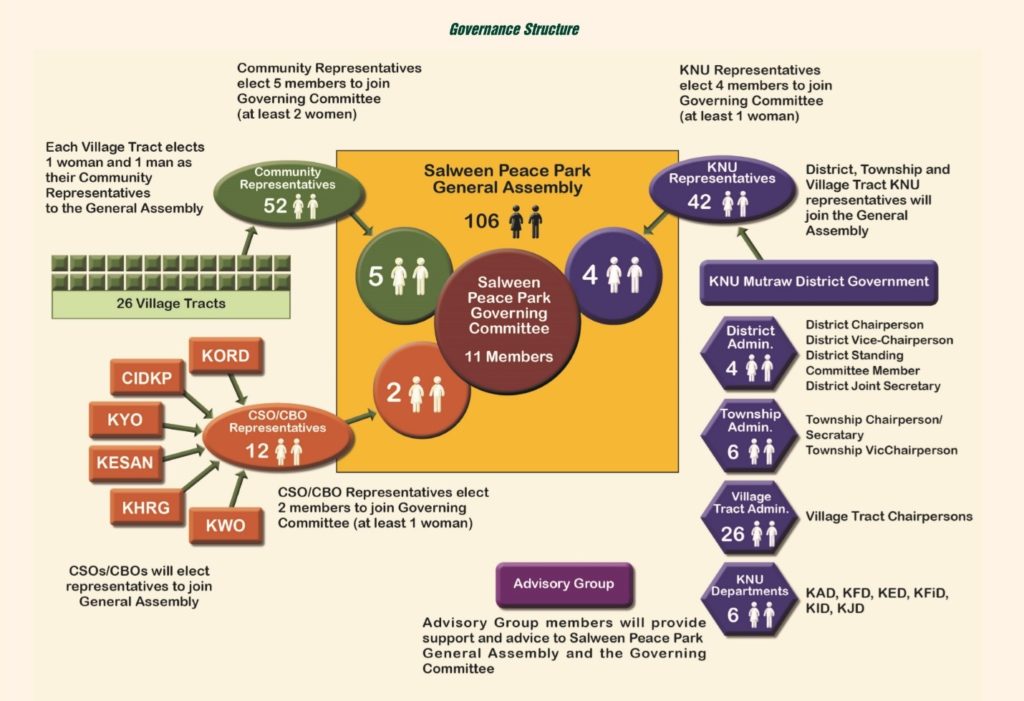
Governance of the Salween Peace Park
The Salween Peace Park’s governance is strongly decentralized, focusing decision-making power in the Karen customary Kaw territories, with a General Assembly that plays a coordinating role. The Peace Park centres community voices, both women and men, in decision-making at every level.
Community-led conservation has set the foundations for the Peace Park over the last decade. These activities include establishing community forests and fish conservation zones. Communities, with assistance from the Karen Forest Department and Karen Environmental and Social Action Network (KESAN), have been documenting traditional Kaw boundaries and reviving Kaw governance systems. The Salween Peace Park builds upon these local initiatives and brings them together to form a representative democratic governance system across the landscape.
Salween Peace Park conservation areas demarcated (2018)
Area in acres
Total area of the Salween Peace Park
1,355,580
248 Kaw
1,026,233
3 Wildlife Sanctuaries
113,324
8 Reserved Forests
123,373
34 Community Forests
36,580
The General Assembly
The Salween Peace Park’s General Assembly was endorsed with the ratification of its Charter in December 2018, and its members were elected in 2019. Comprising 106 popularly elected representatives, the General Assembly is responsible for the overall coordination of the Peace Park area and the development of long-term strategies and targets for the territory (KESAN 2019). It comprises representatives from the KNU, Karen civil society, and one male and one female representative from each of the 26 KNU-defined village tracts inside the territory.
The General Assembly’s executive body, the eleven-member Governing Committee, is tasked with coordinating nine working groups who are responsible at the landscape scale for conflict and dispute resolution, basic infrastructural development (schools, clinics, etc.), external relations, cultural education, and conservation. The groups operate under guidelines established by the Salween Peace Park Charter, which was guided by customary law and Karen tradition and is formally recognised by the Mutraw District KNU.
Governance structure of the Salween Peace Park. Credits: KESAN
The Kaw
The Kaw is the heart of the Salween Peace Park. The Kaw is simultaneously a physical place, a unit of land administration, and a social system, including the cultural, political, and social traditions and customary practices of the Karen people that have been practiced for generations (BEWG 2017). Kaw ancestral territories comprise entire landscapes, understanding the forests, land, waterways, wildlife, and people within as important and interdependent components of a greater whole. The Kaw includes rules and customary practices for managing the land together as part of a holistic, integrated system. Village meetings and committees provide a decentralized system for making decisions, remedying grievances, and resolving disputes, where community members can fulfil their right to self-determination through direct participation and deliberative democracy (Paul 2020).
The primary livelihood is farming, using traditional practices to manage agricultural fields, forests, fisheries, and livestock to meet household needs. Transportation is difficult with poor roads and no public transport infrastructure, limiting connectivity with outside areas in Burma/Myanmar and neighbouring Thailand, but there is a healthy trade network between the Peace Park’s many Kaw (Pimbert et al. 2019).
Family plots within communal upland cultivation areas, or Ku, are demarcated once every cycle (on average 7-10 years) by the Hteepoe Kaw K’sa, who use their knowledge of Karen loola hta poetry and the Kaw’s taboos to identify which areas are suitable for cultivation. Areas of unbroken vegetation and trees are also purposefully left between Ku plots so that arboreal mammals are still able to travel easily around the Kaw. Areas that are considered sacred, or very important to local nature (such as ridges), are never used for cultivation (KESAN 2017).
Traditional agriculture in the Kaw. Photo: KESAN
The spirits of the land, forest, rivers, and wildlife are all greatly respected, leading to the protection of fish spawning areas, sacred forests, mountains, and waterfalls. It is also considered taboo to hunt hornbills, tigers, and gibbons, among other species (KESAN 2019b).
Forests along ridges and riparian forests are protected and not cleared for agriculture. It is taboo to cut trees whose branches are reflected in ponds and rivers. Trees with specific branching patterns where wildlife make their nests are also protected (BEWG 2009).
Forests provide over 150 different non-timber forest products including construction materials, wild foods, and medicinal plants. Karen communities manage their own medicinal herb forests (KESAN 2006).
Sacred forests within the Kaw are protected. These include graveyards and forests where the umbilical cords of newborns are placed inside bamboo containers and tied to trees. The life essence of the child is directly connected to the tree, and if it grows large and strong, the child will have a good and healthy life. Another sacred landscape is the loh¸ areas where the spirit world and the corporeal world meet. When someone dies, a small portion of their body (hair, bones, etc.) is buried in the area so that their spirit may find its way along the spirit path into the next world in preparation for rebirth (Paul 2019).
Thaw Thi Kho mountain, in the north of the Peace Park, is central to many folk tales and is considered sacred by communities all across the Kawthoolei region (KESAN 2020). There are other sacred sites that are strictly protected and can only be visited in the presence of the Hteepoe Kaw K’sa local spiritual leaders.
Settlements, rice fields and forest in balance. Photo: KESAN
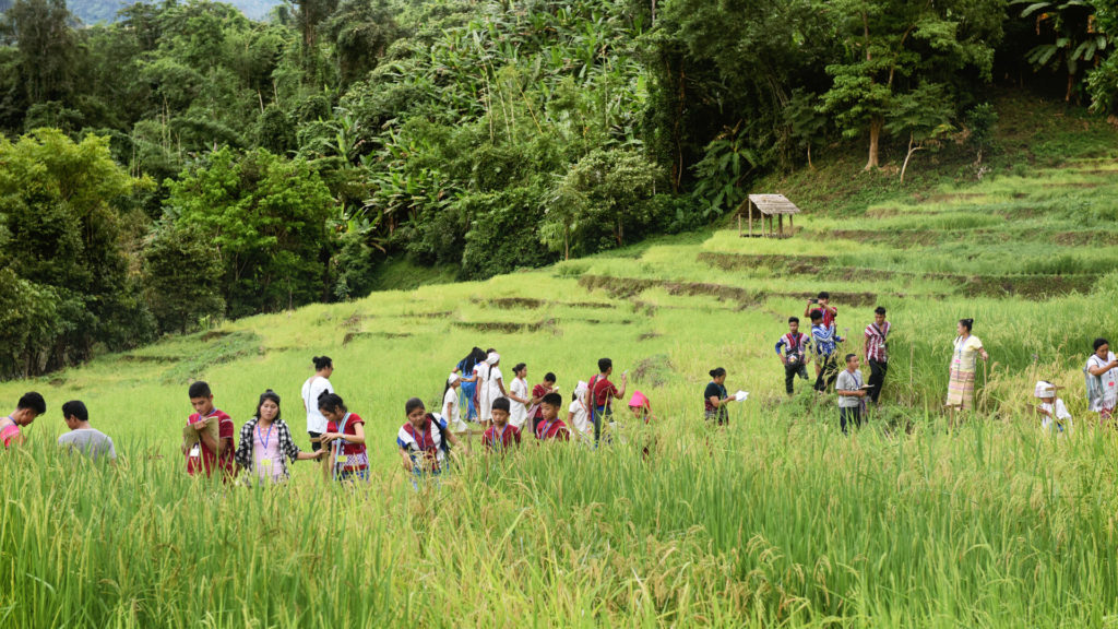
Villagers come together to help harvest rice of their fellow villagers. Photo: KESAN
A traditional trap to protect rotational land from rats. Photo: KESAN
Youth learning how to make traditional textiles from an elder. Photo: KESAN
Wildlife Sanctuaries and Reserved Forests
Within the Salween Peace Park, communities and the KNU (particularly the Karen Forest Department) manage 8 Reserved Forests, 34 community forests, and 3 Wildlife Sanctuaries[8] (covering a total of 540.64 km2). The majority of community forests in the Peace Park are managed directly by communities themselves, as a part of their Kaw, with minor support from the Karen Forest Department, and the rest are co-managed directly with the Department. The Wildlife Sanctuaries are co-managed and the Karen Forest Department, KESAN, and Karen villages conduct research, demarcate boundaries, and develop management rules together.[9]
Conservation values of the Salween Peace Park
The Salween Peace Park is part of the Dawna-Karen hills ecoregion. Forests include lowland dry dipterocarp forest, teak forests, mixed deciduous forest around 100-800 metres above sea level, evergreen forest from 300-1,000 masl, subalpine forest around 800-2000 masl, and montane evergreen forest over 1,000 masl.
These forests are home to the critically endangered sunda pangolin, endangered species such as tigers, Asian elephants, dhole, gibbons, and banteng, many vulnerable species such as leopards, Asiatic black bears, sun bears, and gaur, and 35 other species protected by the Convention on International Trade in Endangered Species of Wild Fauna and Flora (SBB Moo et al. 2017). Research teams have documented 93 species of orchids in the Peace Park. Initial camera trap data indicate thriving wildlife populations, with an intact and diverse assemblage of carnivores living in the same areas (19 species have been documented so far) supported by a robust prey base, including the sambar deer, which has been heavily hunted through much of the Indo-Burma region.
Marbled cat (Pardofelis marmorata), Asiatic golden cat (Catopuma temminckii), Chinese serow (Capricornis milneedwardsii)
IUCN Red List Status of species found within the Salween Peace Park
The Salween Peace Park is the northern end of the forest corridor that stretches across Myanmar and Thailand that offers the best hope for tiger conservation in the region, with a source breeding population in Thailand’s Western Forest Complex. The Park is also home to one of the most significant breeding populations of Indochinese leopards (P.p delacouri) remaining in Southeast Asia, which now lives on only 2.5 per cent of its range (Moo et al. 2017).
This ecological health and diversity are outstanding in the country and in the Mekong region, which has seen dramatic declines in wildlife species over the past few decades of intensified hunting and wildlife trade, large scale land grabs, agribusiness, and resource extraction.
Commemoration of International Day of Action for Rivers and Against Dams. Photo: KESAN
The Salween River
The Salween River is the longest free-flowing river in Asia, and plays a central role in the livelihoods of the people and health of the environment of the Peace Park. It is threatened by a series of mainstream hydropower mega dams planned during Burma’s previous military regime. The most prominent of these is the 1350 MW Hatgyi dam, proposed in 2001 as a joint venture between the Burmese Government, China’s Sinohydro, and the Electricity Generating Authority of Thailand.
The establishment of the Salween Peace Park is a grassroots declaration of opposition to the Hatgyi dam, the construction site of which lies directly at the Park’s southern tip. Should it be constructed, it would displace tens of thousands of people, cause coastal erosion, damage fisheries, threaten endemic fish with extinction,[10] flood two wildlife sanctuaries, and directly impact the livelihoods of the 10 million people fishing, farming, and living in the Salween River basin. These planned dams would cause irreparable damage to the 2,800-km river’s ecology, geomorphology, and flow. As the southernmost of the planned mainstream dams, building the Hatgyi Dam alone would disconnect 91% of the river basin’s aquatic habitat from the sea, altering flow regimes and blocking sediment that would cause coastal erosion and significant reductions in river and coastal fisheries productivity (IFC 2018).
Conclusion
The Salween Peace Park is an Indigenous Karen declaration of hope. The region is beset by conflict, threatened by large-scale extractive projects, and encroaching impacts of the global climate emergency. In response, Indigenous Karen communities have brought together key stakeholders and united them behind their vision for an ecologically sound, just, and peaceful landscape. Built upon a foundation of Indigenous knowledge and generations of Karen stewardship, the Salween Peace Park offers stability to its people and wildlife, and a valuable learning opportunity both for Burma’s governing bodies and the wider world. Through the Peace Park, and with the support of other territories of life around the world, Mutraw’s Indigenous Karen offer us an alternative vision of the future; a place where all things can live together in peace.
Moo, Saw Sha Bwe, G.Z.L. Froese, T.N.E. Gray. 2017. “First Structured Camera-Trap Surveys in Karen State, Myanmar, Reveal High Diversity of Globally Threatened Mammals.” Oryx 52: 3.
Paul, A. 2019. With the Salween Peace Park we can survive as a nation: Karen Environmental Relations and the Politics of an Indigenous Conservation Initiative.
[1] Documented by a community-led team of women researchers in Khehsor Ter community forest Luthaw Township, Mutraw District. More information can be found in Karen language in the KESAN report Studying Orchids, Enriching Lives (2018): http://kesan.asia/resource/studying-orchids-enriching-lives/
[2] The Karen National Union is the de facto governing body in Karen territory, and the civilian government of the Karen independence movement. The KNU is both lead negotiator in ongoing peace negotiations, and the primary governing body and service provider in Karen governed areas. Its departments have been responsible for public education, land and forest governance, public healthcare, fisheries, and courts of law, among other government services, across Kawthoolei since the KNU’s founding in 1947. More information can be found at www.knuhq.org.
[3] Burma’s army, comprising its territorial army, navy, and air force.
[4] The Government of the Republic of the Union of Myanmar, headquartered in Nay Pyi Taw and governed by the National League for Democracy led State Counsellor Aung San Suu Kyi and President Win Myint. The Tatmadaw (junta) staged a military coup and overthrew the democratically elected government on 1 February 2021. At the time of publication in April 2021, the crisis has not yet been resolved. For more information, see the ICCA Consortium’s open letter and call to action on the situation in Myanmar, published on 5 April 2021.
[8] These Wildlife Sanctuaries were formally gazetted by the British and are now being revitalized by the Karen Forest Department, KESAN, and local communities to be actively managed and protected.
[9] Kaydoh Mae Nyaw, for example, was established in 2017 after five years of collaboration with 43 villages surrounding the Wildlife Sanctuary and two villages within its boundaries. Villages can continue to cultivate their established farms and orchards, and have set 10 rules to guide expanding and establishing new cultivation areas. Research has documented 64 mammal, 122 bird, 12 amphibian, and 20 reptile species in the Wildlife Sanctuary (KESAN 2016).
[10] In the river basin, 170 fish species have been documented, 60 of which are endemic. Community-led research has identified 90 species of fish downstream of the planned Hatgyi dam site (KESAN 2015).
About the authors
Saw Paul Sein Twa is an Indigenous Karen leader, Chairperson of the Salween Peace Park General Assembly and Director of the Karen Environmental and Social Action Network (KESAN, ICCA Consortium Member). He has worked with Karen communities in the Salween Peace Park area for over two decades. He is also a Council member of the ICCA Consortium and recipient of the 2020 Goldman Environmental Prize for Asia.
Julia Fogerite is an environmental researcher who has worked on biodiversity conservation, land tenure, and environmental governance in Burma since 2013 and an Honorary member of the ICCA Consortium.
Casper Palmano is a technical advisor at the Karen Environmental and Social Action Network and has worked on natural resource and territory rights issues in Burma since 2014 and an Honorary member of the ICCA Consortium.
On 1 February 2021, the military staged a coup d’état in Burma/Myanmar, sparking nation-wide demonstrations in an unprecedented surge of civic mobilization. The military has responded with brutal force and myriad repressive tactics. On 27 March 2021, it began a series of deadly airstrikes on Indigenous Karen villages in the heart of the award-winning Salween […]


 Settlements, rice fields and forest in balance. Photo: KESAN
 Villagers come together to help harvest rice of their fellow villagers. Photo: KESAN
 A traditional trap to protect rotational land from rats. Photo: KESAN
 Youth learning how to make traditional textiles from an elder. Photo: KESAN